Displaying 1 - 7 of 7
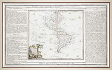
L'Amérique Dressée pour l'étude de la Géographie,: revue et augmentée par Mr. Brion,…
Description: This is a map of the Americas with the northwestern part of North America left undefined. It shows more large lakes to the west of the Great Lakes and a river route to the Pacific, which was believed… more
Type: chorographic maps
Date Created: 1786
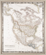
North America: By Sidney Hall.
Description: Framed map of North America. The map shows North America and parts of South America, Greenland and Russia (including the territory that is now Alaska). Part of present-day British Columbia, including… more
Publisher: Longman, Rees, Orme, Brown & Green
Type: chorographic maps
Date Created: 1829-08-01
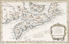
Carte de l'Accadie et Païs Voisins pour servir a l'Histoire Generale des Voyages: Par M.B…
Description: Rectangular map engraved on paper; framed and covered with glass. Coloured. Depicts Nova Scotia, P.E.I., Cape Breton, and part of New Brunswick; all place names in French. Highland areas in brown.… more
Province: Nova Scotia, New Brunswick, Prince Edward Island
Type: chorographic maps
Date Created: 1757
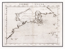
Tierra Nueva
Description: Rectangular black and white engraved map on paper; framed under glass. Map depicts eastern part of Canada including Cape Breton and Newfoundland. Shape rectangular Additional associations Frame HF.94… more
Type: chorographic maps
Date Created: 1561
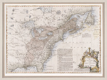
A Map of the British and French Settlements in North America
Description: Framed map; presenting French territories as far south as the mouth of the Mississippi. The map shows bodies of water such as, the Hudson's Bay, the Great Lakes, Northren mountains, fishing… more
Type: chorographic maps
Date Created: 1760 (year approximate)

Carta Geographica Del Canada Nell' America Settentrionale
Description: Framed map of Canada; cartouche top left corner: natives by a pond with deer and animals which are part dog, part fish. The map shows bodies of water such as Baja D' Hudson, villages, towns, and… more
Type: chorographic maps
Date Created: 1700 to 1799

Plan Shewing the position of the Northern points of Commencement of the Lines dividing Lots 33 and…
Description: The map shows northern portions of Lots 24, 33, 34 and 35 along the north shore of Prince Edward Island. It shows the northern-most sections of three boundary lines: the line dividing Lots 24 and 33… more
Province: Prince Edward Island
Type: chorographic maps
Date Created: 1835-05-07