Displaying 1 - 2 of 2
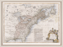
A Map of the British and French Settlements in North America
Description: Framed map; presenting French territories as far south as the mouth of the Mississippi. The map shows bodies of water such as, the Hudson's Bay, the Great Lakes, Northren mountains, fishing… more
Type: chorographic maps
Date Created: 1760 (year approximate)

Carta Geographica Del Canada Nell' America Settentrionale
Description: Framed map of Canada; cartouche top left corner: natives by a pond with deer and animals which are part dog, part fish. The map shows bodies of water such as Baja D' Hudson, villages, towns, and… more
Type: chorographic maps
Date Created: 1700 to 1799