Displaying 568 - 594 of 603
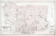
Plan of Charlottetown Royalty: Queens Co., P.E.I.
Description: The map shows the city of Charlottetown and a plan for lots. Shown are rivers, creeks, roads, railroad and stations, landowners and acreage, mills, park, bridge, college, farms, asylums, and a… more
Publisher: J. H. Meacham & company
Province: Prince Edward Island
Type: cadastral maps
Date Issued (Source): 1880
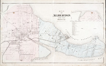
Map of Alberton Lots 4 & 5: Prince Co., P.E.I.
Description: The map shows lots 4 & 5 in the town of Alberton, Prince county. Shown are rivers, creeks, lakes, wharfs, shipyard, roads, railroad, landowners and acreage, mills, churches and cemetery. Compass… more
Publisher: J. H. Meacham & company
Province: Prince Edward Island
Type: cadastral maps
Date Issued (Source): 1880
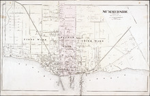
Summerside: Prince Co.
Description: The map shows the city of Summerside. Shown are the wards, roads, landowners and acreage, harbour, barracks, schools, squares, shipyards, railroad and station, and wharfs. Compass.
Publisher: J. H. Meacham & company
Province: Prince Edward Island
Type: cadastral maps
Date Issued (Source): 1880
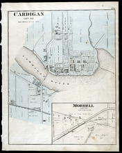
Cardigan Lot 53: Morrell Lot 40
Description: The map shows lot 53 in Cardigan. Shown are a river, roads, railroads, lots, landowners, school house, buildings, houses, wharfs and creeks. Compass.
Publisher: J. H. Meacham & company
Province: Prince Edward Island
Type: cadastral maps
Date Issued (Source): 1880

Montague Bridge Lots 59 & 52: Kings Co., P.E.I.
Description: The map shows lots 59 & 52 in Montague Bridge, Kings county. Shown are rivers, wharfs, shipyards, roads, landowners and acreage, halls, churches, buildings and businesses. Compass.
Publisher: J. H. Meacham & company
Province: Prince Edward Island
Type: cadastral maps
Date Issued (Source): 1880
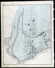
Souris
Description: The map shows a part of Souris. Shown are the Souris river, sand beach, roads, railroads, churhces, landowners, houses, buildings and businesses. Compass
Publisher: J. H. Meacham & company
Province: Prince Edward Island
Type: cadastral maps
Date Issued (Source): 1880
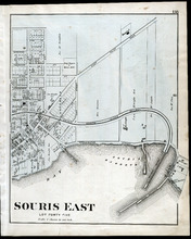
Souris East: Lot Forty Five
Description: The map shows Lot 45 in Souris East. Shown are the Souris Harbour and Bay, wharfs, roads and streets, railroads, lobster factory, landowners, houses, buildings and businesses. Compass
Publisher: J. H. Meacham & company
Province: Prince Edward Island
Type: cadastral maps
Date Issued (Source): 1880
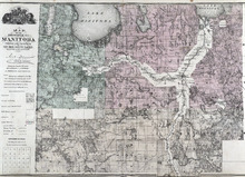
Map of the Province of Manitoba
Description: The map shows the province of Manitoba. Shown on the side are a Reference table and a Township diagram, lakes, roads, marshes, Indian Reserves, churches, rivers, and ponds. Compass.
Publisher: J. H. Meacham & company
Province: Manitoba
Type: cadastral maps
Date Issued (Source): 1880
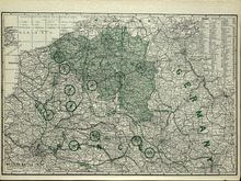
Western Battle Front
Description: The map shows the Western Battle Front in France, Belgium, and Germany. Shown are fortresses and fortified towns, forts, airship bases, wireless stations, railways, highways, and canals.
Publisher: Cummins Map Co.
Type: cadastral maps
Date Issued (Source): 1927
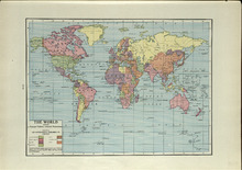
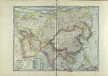
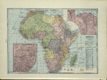
The World: Showing Principal Nations' Colonial Possessions
Description: The map shows the world and colonial possessions. Shown is a coloured table of the principal Nations' Colonial Possessions, countries, oceans and coordinates. more
Publisher: Cummins Map Co.
Type: cadastral maps
Date Issued (Source): 1927
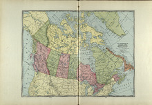
The Dominion of Canada and Newfoundland
Description: The map shows the dominion of Canada and Newfoundland. Shown are all provinces, territories, Greenland, and United States, oceans, bays, and mountains.
Publisher: Cummins Map Co.
Type: cadastral maps
Date Issued (Source): 1927
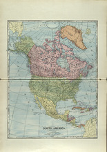
North America
Description: The map shows North America. Shown is the dominion of Canada, United States, Mexico, Central America, bodies of water, and coordinates.
Publisher: Cummins Map Co.
Type: cadastral maps
Date Issued (Source): 1927
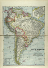
South America
Description: The map shows South America. Shown is a table of Political Divisions of South America with area and population, capitals of countries and states, railroads and telegraph lines, bodies of water,… more
Publisher: Cummins Map Co.
Type: cadastral maps
Date Issued (Source): 1927
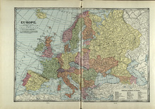
Europe
Description: The map shows the country of Eroupe. Shown are capitals of countries, railroads, submarine telegraph lines, a table of Principal Divisions of Europe, bodies of water, and coordinates.
Publisher: Cummins Map Co.
Type: cadastral maps
Date Issued (Source): 1927
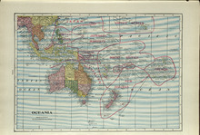
Oceania
Description: The map shows the Oceania. Shown are the Topic of Capricorn and the Equator lines, countries, great sand deserts, bodies of water, cities, and towns.
Publisher: Cummins Map Co.
Type: cadastral maps
Date Issued (Source): 1927
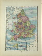
England and Wales
Description: The map shows England and Wales/ Shown are the North and Irish Sea, St. Patrick's, St. George's, Britol, and English Channel, cities and towns. more
Publisher: Cummins Map Co.
Type: cadastral maps
Date Issued (Source): 1927
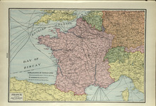
France
Description: The map shows France. Shown are a table of an Explaination of Battle Lines, English Channel, Bay of Biscay, cities, and towns.
Publisher: Cummins Map Co.
Type: cadastral maps
Date Issued (Source): 1927
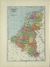
Netherlands, Belgium and Luxemburg
Description: The map shows the Netherlands, Belgium and Luxemburg. Shown are the North Sea, towns, and cities.
Publisher: Cummins Map Co.
Type: cadastral maps
Date Issued (Source): 1927
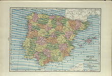
Spain and Portugal
Description: The map shows Spain and Portugal. Shown are The Atlantic Ocean, Mediterranean Sea, Balearic Islands, Bay of Biscay, Gulf of Lyons, Pyrenees Mountains, towns, and cities.
Publisher: Cummins Map Co.
Type: cadastral maps
Date Issued (Source): 1927
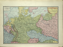
Germany
Description: The map shows Germany. Shown are the North and Baltic Sea, cables, Towns, and Cities.
Publisher: Cummins Map Co.
Type: cadastral maps
Date Issued (Source): 1927
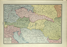
Austria, Hungary and Czecho-Slovakia
Description: The map shows Austria, and Hungary and Czecho-Slovakia. Shown are other countries, towns, and cities, and the Adriatic Sea.
Publisher: Cummins Map Co.
Type: cadastral maps
Date Issued (Source): 1927
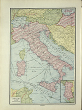
Italy
Description: The map shows Italy. Shown are the Adriatic, Tyrrhenian, Mediterranean, and Sicilian Sea, cables, countries, cities, and towns.
Publisher: Cummins Map Co.
Type: cadastral maps
Date Issued (Source): 1927
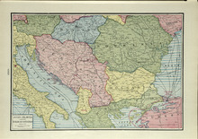
Jugo-Slavia and the Balkan-States
Description: The map shows Jugo-Slavia and the Balkan-States. Shown are the Black, Adriatica, and Aegean Sea, cables, towns, and cities.
Publisher: Cummins Map Co.
Type: cadastral maps
Date Issued (Source): 1927