Displaying 28 - 54 of 77
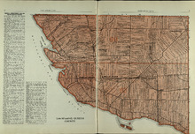
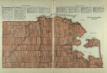
Lots 60 and 62: Queens County
Description: The map shows lots 60 and 62 in Queens county. Shown are the Northumberland Strait, roads, railroads, harbour, points, landowners, and acreage.
Publisher: Cummins Map Co.
Province: Prince Edward Island
Type: cadastral maps
Date Issued (Source): 1927
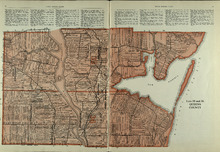
Lots 35 and 36: Queens County
Description: The map shows lots 35 and 36 in Queens County. Shown are Hillsborough River, Tracadie Bay, Gulf of St. Lawrence. Mill Cove, landowners, acreage, raods, and railroads.
Publisher: Cummins Map Co.
Province: Prince Edward Island
Type: cadastral maps
Date Issued (Source): 1927
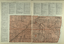
Lot 37, Queens County: Lot 38 Kings County
Description: The map shows lot 37 in Queens county and lot 38 in Kings county. Shown are the Gulf of St. Lawrence, Savage Harbour, landowners, acreage, roads, railroads, and rivers.
Publisher: Cummins Map Co.
Province: Prince Edward Island
Type: cadastral maps
Date Issued (Source): 1927
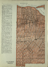
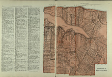
Lot 39: Kings County
Description: The map shows lot 39 in Kings county. Shown are the Gulf of St. Lawrence, St. Peters bay, landowners, acreage, roads, railroads, Stukeley Ponds, and sands hills.
Publisher: Cummins Map Co.
Province: Prince Edward Island
Type: cadastral maps
Date Issued (Source): 1927
Lots 40 and 41: Kings County
Description: The map shows lots 40 and 41 in Kings county. Shown are the Gulf of St. Lawrence, St. Peters Bay, landowners, acreage, roads, and railroads.
Publisher: Cummins Map Co.
Province: Prince Edward Island
Type: cadastral maps
Date Issued (Source): 1927
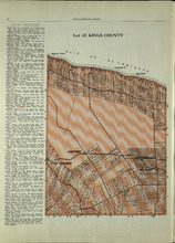
Lot 42: Kings County
Description: The map shows lot 42 in Kings county. Shown are the Gulf of St. Lawrence, points, landowners, acreage, roads, and railroads.
Publisher: Cummins Map Co.
Province: Prince Edward Island
Type: cadastral maps
Date Issued (Source): 1927
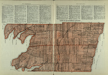
Lots 43 and 44 : Kings County
Description: The map shows lots 43 and 44 in Kings county. Shown are the Gulf of St. Lawrence, bays, points, rivers, landowners, acreage, roads, and railroads.
Publisher: Cummins Map Co.
Province: Prince Edward Island
Type: cadastral maps
Date Issued (Source): 1927
Lot 45: Kings County
Description: The map shows lot 45 in Kings county. Shown are the Gulf of St. Lawrence, Colville bay, landowners, acreage, roads, and railroads.
Publisher: Cummins Map Co.
Province: Prince Edward Island
Type: cadastral maps
Date Issued (Source): 1927
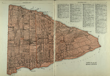
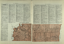
Lots 46 and 47 : Kings County
Description: The map shows lots 46 and 47 in Kings county. Shown are the Gulf of St. Lawrence, points, rivers, coves, landowners, acreage, roads, railroads, lakes, and sand.
Publisher: Cummins Map Co.
Province: Prince Edward Island
Type: cadastral maps
Date Issued (Source): 1927
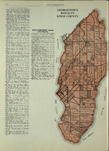
Georgetown Royalty: Kings County
Description: The map shows Georgetown Royalty in Kings county. Shown are landowners, acreage, Brudenell and Cardigan River, Albion Bay, roads, and railroads.
Publisher: Cummins Map Co.
Province: Prince Edward Island
Type: cadastral maps
Date Issued (Source): 1927
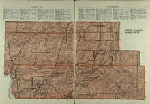
Lots 51, 52, and 66: Kings County
Description: The map shows lots 51, 52, and 66 in Kings County. Shown are Brown Creek, Montague River, Landowners, acreage, roads, and railroads.
Publisher: Cummins Map Co.
Province: Prince Edward Island
Type: cadastral maps
Date Issued (Source): 1927
Lots 55 and 56: Kings County
Description: The map shows lots 55 and 56 in Kings county. Shown are bays, rivers, ponds, landowners, acreage, roads, coves, and Boughton Island.
Publisher: Cummins Map Co.
Province: Prince Edward Island
Type: cadastral maps
Date Issued (Source): 1927
Lots 59 and 61: Kings County
Description: The map shows lots 59 and 61 in Kings county. Shown are Montague river, bays, points, coves, landowners, acreage, roads, creeks, and Panamure Island.
Publisher: Cummins Map Co.
Province: Prince Edward Island
Type: cadastral maps
Date Issued (Source): 1927
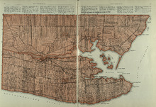
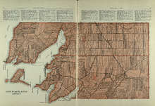
Lots 63 and 64: Kings County
Description: The map shows lots 63 and 64 in Kings county. Shown are Northumberland Strait, Gulf of St. Lawrence, Murray Harbour, Island and River, points, Herring Ponds, landowners, acreage, roads, and railroads.
Publisher: Cummins Map Co.
Province: Prince Edward Island
Type: cadastral maps
Date Issued (Source): 1927
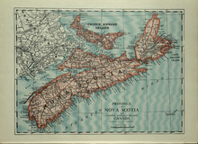
Province of Novia Scotia and Prince Edward Island Canada
Description: The map shows the Provinces of Novia Scotia and Prince Edward Island Canada. Shown are Cape Breton Island, New Brunswick, Atlantic Ocean, Sable Island, Northumberland Strait, Bay of Fundy, roads,… more
Publisher: Cummins Map Co.
Province: Nova Scotia, Prince Edward Island, Cape Breton Island, New Brunswick
Type: cadastral maps
Date Issued (Source): 1927
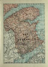
Province of New Brunswick and part of Quebec, Canada
Description: The map shows the Provinces of New Brunswick and part of Quebec, Canada. Shown are Prince Edward Island, United States, Nova Scotia, St. Lawrence River and Gulf, Northumberland Strait, Bay of Fundy,… more
Publisher: Cummins Map Co.
Province: Nova Scotia, Prince Edward Island, Quebec, New Brunswick
Type: cadastral maps
Date Issued (Source): 1927
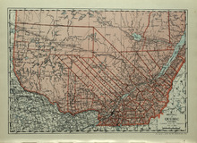
Province of Quebec, Canada
Description: The map shows the province of Quebec in Canada. Shown are Ontario, New York, Maine, towns, cities, raods, railroads, and St. Lawrence River.
Publisher: Cummins Map Co.
Province: Quebec
Type: cadastral maps
Date Issued (Source): 1927
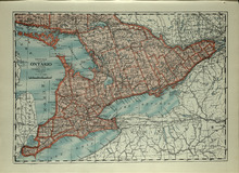
Province of Ontario, Canada
Description: The map shows the Province of Ontario, Canada. Shown are Georgian Bay, Lake Ontario, Erie, and Huron, Michigan, New York, roads, towns and cities.
Publisher: Cummins Map Co.
Province: Ontario
Type: cadastral maps
Date Issued (Source): 1927
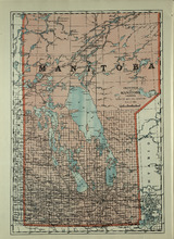
Province of Manitoba, Canada
Description: The map shows the province of Manitoba, Canada. Shown are the lakes, rivers and other bodies of water, and railroads.
Publisher: Cummins Map Co.
Province: Manitoba, Saskatchewan, Ontario
Type: cadastral maps
Date Issued (Source): 1927
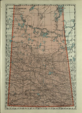
Province of Saskatchewan, Canada
Description: The map shows the province of Saskatchewan, Canada. Shown are rivers, lakes, and other bodies of water, roads, and railroads.
Publisher: Cummins Map Co.
Province: Saskatchewan, Alberta, Mantitoba
Type: cadastral maps
Date Issued (Source): 1927
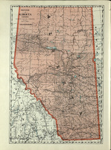
Province of Alberta, Canada
Description: The map shows the province of Alberta, Canada. Shown are bodies of water, rivers, lakes, etc., cities and towns, roads and railroads.
Publisher: Cummins Map Co.
Province: Alberta, British Columbia, Saskatchewan
Type: cadastral maps
Date Issued (Source): 1927
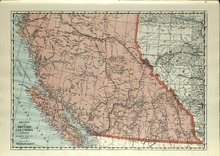
Province of British Columbia, Canada
Description: The map shows the province of British Columbia, Canada. Shown are the Pacific Ocean, Rocky Mountains, Vancouver Island, mountains, roads, and railroads.
Publisher: Cummins Map Co.
Province: British Columbia, Alberta
Type: cadastral maps
Date Issued (Source): 1927
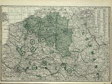
Western Battle Front
Description: The map shows the Western Battle Front in France, Belgium, and Germany. Shown are fortresses and fortified towns, forts, airship bases, wireless stations, railways, highways, and canals.
Publisher: Cummins Map Co.
Type: cadastral maps
Date Issued (Source): 1927
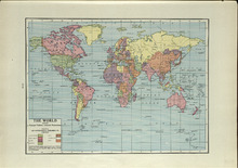
The World: Showing Principal Nations' Colonial Possessions
Description: The map shows the world and colonial possessions. Shown is a coloured table of the principal Nations' Colonial Possessions, countries, oceans and coordinates. more
Publisher: Cummins Map Co.
Type: cadastral maps
Date Issued (Source): 1927
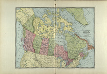
The Dominion of Canada and Newfoundland
Description: The map shows the dominion of Canada and Newfoundland. Shown are all provinces, territories, Greenland, and United States, oceans, bays, and mountains.
Publisher: Cummins Map Co.
Type: cadastral maps
Date Issued (Source): 1927
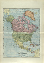
North America
Description: The map shows North America. Shown is the dominion of Canada, United States, Mexico, Central America, bodies of water, and coordinates.
Publisher: Cummins Map Co.
Type: cadastral maps
Date Issued (Source): 1927
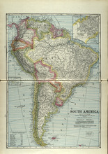
South America
Description: The map shows South America. Shown is a table of Political Divisions of South America with area and population, capitals of countries and states, railroads and telegraph lines, bodies of water,… more
Publisher: Cummins Map Co.
Type: cadastral maps
Date Issued (Source): 1927