Displaying 1 - 27 of 220

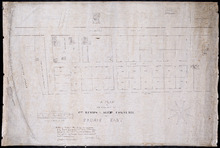
Plan of that portion of the town of Summerside laid off on the front of the farm by Mr. Jesse Green.
Description: Plan of that portion of the town of Summerside laid off on the front of the farm by Mr. Jesse Green. The map shows lots, residents, towns, cities, roads, and bodies of water.
Province: Prince Edward Island
Type: cadastral maps
Date Created: 1868-11-25
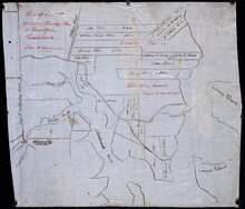
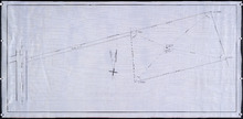
A Plan of the Property of Capt. Simon and Alexander Cheverie: in Souris East
Description: A plan of the property of Capt. Simon and Alexander Cheverie in Souris East. The map shows lots, acreage, roads/streets, and buildings.
Province: Prince Edward Island
Type: cadastral maps
Date Created: 1879-06-18

Common Lot No 21 as divided into Building Lots
Description: Plan of Common Lot No.21. Charlottetown as divided into building lots. (No.380) The map shows lots, acreage and roads/streets.
Province: Prince Edward Island
Type: cadastral maps
Date Created: 1872-08

Plan of Lot 5
Description: Plan of Lot 5. Shows names of residents and acreage, rivers, creeks, roads, bays and Islands.
Province: Prince Edward Island
Type: cadastral maps

Plan of George Town: The Town Lots are 84 by 120 Feet. The North and South Streets are 100 Feet.…
Description: Plan of Georgetown showing lots and streets, bays, ranges, squares, and a school house. Also shows location of school house. Copy from the Office Plan No.6.
Province: Prince Edward Island
Date Created: 1853-06-07

A Plan of Township No 4 Part of the Cunard Estate Prince County P.E.Island
Description: A plan of Lot 4, part of the Cunard Estate. Copied from plans in the Public Lands Department. The map shows lots, residents, bodies of water such as rivers, railways, and roads.
Province: Prince Edward Island
Type: cadastral maps
Date Created: 1885-06
Part of Lot 12 : copied from Township Plan in Land Office Charlottetown
Description: Plan of part of Lot 12 - North Shore. Shows names of some residents, acreage, roads, creeks, Islands, towns and cities. Copied from Township Plan in the Land Office at Charlottetown.
Province: Prince Edward Island
Type: cadastral maps

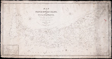
Map of Prince Edward Island
Description: Map of Prince Edward Island. Shows roads, ponds, rivers, towns, cities, grist mills, saw mills, and churches.
Province: Prince Edward Island
Type: cadastral maps

Plan Shewing lands in Charlottetown Appropriated fro Railway purposes : The Figures 67 &c.…
Description: Plan showing lands in Charlottetown appropriated for Railway purposes. The map shows lots, residents, streets, and wharfs.
Province: Prince Edward Island
Type: cadastral maps
Map of Prince Edward Island, in the Gulf of St. Lawrence: Comprising the latest Topographical…
Description: Map of Prince Edward Island by George Wright, Surveyor General, 1852. Shows mail routes, roads, churches, water mills, population, boundaries, and post offices.
Province: Prince Edward Island
Type: cadastral maps
Date Created: 1852

Plan of North River from Victoria Park to North River Bridge: Showing Subdivisions to be leased for…
Description: Plan of North River from Victoria Park to North River Bridge showing subdivisions to be leased for Oyster Culture. (No.5) The map shows residents, lots, measurements, and roads.
Province: Prince Edward Island
Type: cadastral maps
Date Created: 1913-02-15
Plan showing 0.604 acres of land acquired from Leo Praught, Lot 50, for the Provincial Highway
Description: Plan showing 0.604 acres of land acquired from Leo Praught, Lot 50, for the Provincial Highway. The map shows measurements, acres, some residents and roads and where those roads lead too.
Province: Prince Edward Island
Type: cadastral maps
Date Created: 1939-05
Plan of part of Lot 49: Tea Hill, Charlottetown Exchange.
Description: Plan of part of Lot 49. Tea Hill. Charlottetown Exchange. Shows property owned by the Island Telephone Co. Ltd. (Grid co-ordinates)
Province: Prince Edward Island
Type: cadastral maps

Plan of Charlotte Town Shewing the true position of the Streets and the encroachments thereon.…
Description: The map shows the street grid, numbered town lots and public squares of Charlottetown. It shows some buildings and some of the roads leading to/from the town.
Province: Prince Edward Island
Type: plans
Date Created: 1833
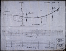
Plan of Proposed Railway Crossing North River to Mount Edward Roads
Description: Plan of proposed Railway crossing North River to Mount Edward Road. Department of Public Works and Highways, Province of Prince Edward Island. Plan shows 3 drawings consisting of the Railway &… more
Province: Prince Edward Island
Type: cadastral maps, transportation maps
Date Created: 1949

Plan of that part of Lot or Township No. 55, lying North: lying North of Boughton River shewing the…
Description: Plan of that part of Lot or Township 55 lying north of Boughton River showing the situation of the respective plots as coloured green which are still in the Crown. The map shows bodies of water such… more
Province: Prince Edward Island
Type: cadastral maps
Date Created: 1845

Lot 6: No. 19
Description: Plan of Lot 6 (No. 19). Cunard Estate. Shows names of residents, acreage, and some land conveyance references, bodies of water such as rivers, and roads.
Province: Prince Edward Island
Type: cadastral maps
Plan of part of The Western Road.: W. Curtis
Description: (No. 46). The map shows a plan of the Western Road from St. Eleanor's to Lot 10. The road passes through Lots 10, 11, 12, 13, 14, 16 and 17. The map shows part of the Ellis River and other… more
Province: Prince Edward Island
Type: plans

Plan of Township No. 4: Compiled from the plans, leases, deeds, and other documents on file in the…
Description: The map shows Lot 4 divided into parcels of land with the names of residents, their acreage amounts and land conveyance references. The map shows roads in a light brown colour. It shows the P.E.I.… more
Province: Prince Edward Island
Type: cadastral maps
Date Created: 1911-06
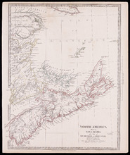
North America Sheet 1 : Nova Scotia with part of New Brunswick and Lower Canada
Description: North America, sheet 1, Nova Scotia with part of New Brunswick and Lower Canada. Published by Society for the Diffusion of Useful Knowledge. The map shows provinces, bodies of water, cities and towns… more
Province: Prince Edward Island, New Brunswick, Nova Scotia
Type: cadastral maps
Date Created: 1832-12-15

Prince Edward Island Nova Scotia and New Brunswick: Prince, Queens and Kings Counties, P.E.I.…
Description: Prince, Queens and Kings Counties, Prince Edward Island, portions of New Brunswick, Nova Scotia, and Magdalen Islands. It marks counties, parishes, cities, towns, and villages, beaches, marshes, Lots… more
Publisher: Hydrographic and Map Service, Labelle Building
Province: Prince Edward Island, Nova Scotia, New Brunswick, Quebec
Type: cadastral maps
Date Created: 1940

Plan of Lot or Township No 4, in P.E. Island: The shores and the division Lines coloured according…
Description: Plan of Lot 4. The shores and the division lines colored to yellow are according to actual survey. Shows names of some residents, acreage, roads, and bodies of water such as rivers.
Province: Prince Edward Island
Type: cadastral maps

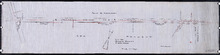
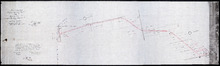
Plan of a Line of Road from Montague River Bridge to Wood Islands: Run in November 1833
Description: Plan of a line of road from Montague River Bridge to Wood Islands. Passes through Lots 59, 60, 61, and 62. (No.59). Shown are residents, lots, and rivers.
Province: Prince Edward Island
Type: cadastral maps
Date Created: 1833-11

Plan of Lot No 1 Shewing the Extent of the Fishery Reserve to the Crown and situation of settlers…
Description: Plan of Lot 1 (No.6) showing the extent of the Fishery Reserve to the Crown and situation of settlers thereon. Also the site of the respective fishery establishments of the same, as delineated from… more
Province: Prince Edward Island
Type: cadastral maps
Date Created: 1853-10
P.E.I. Railway Murray Harbour Branch : Plan Branch Line From Village Green to Vernon River Bridge
Description: Prince Edward Island Railway. Murray Harbour Branch. Plan of the branch line from Village Green to Vernon River Bridge (No.588). Plan produced by Wm. B. MacKenzie, Chief Engineer. The map shows lots… more
Province: Prince Edward Island
Type: cadastral maps
Date Created: 1906-05-28
Plan No 1 Office of the Registar of Deeds: Charlottetown P.E.Island
Description: Plan of land appropriated for the construction of the Murray Harbour Branch Railway through Queen's County (No.1). Plan produced by Wm. B. MacKenzie, Chief Engineer. The map shows residents,… more
Province: Prince Edward Island
Type: cadastral maps
Date Created: 1900-06-07
Plan of Cape Traverse Branch: Prince Edward Island Railway
Description: Canadian Government Railways, Prince Edward Island. Cape Traverse subdivision. Plans of the Railway right of way from Emerald Junction to Port Borden. Copied from the plans in the Engineer's… more
Province: Prince Edward Island
Type: cadastral maps