Displaying 1 - 27 of 34
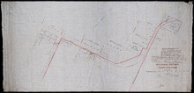
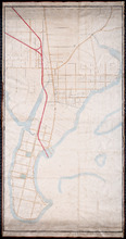
P.E.Island Railway: Charlottetown
Description: Prince Edward Island Railway. Charlottetown. Appropriations into Charlottetown Station. The map shows roads, streets, lots, and buildings.
Province: Prince Edward Island
Type: plans
Date Created: 1871

A Plan of Township No 4 Part of the Cunard Estate Prince County P.E.Island
Description: A plan of Lot 4, part of the Cunard Estate. Copied from plans in the Public Lands Department. The map shows lots, residents, bodies of water such as rivers, railways, and roads.
Province: Prince Edward Island
Type: cadastral maps
Date Created: 1885-06
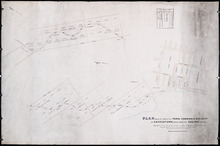
Plan Shewing Lands in the Town, Common, and Royalty of Georgetown appropriated for Railway purposes…
Description: Plan showing lands in the Town, Common, and Royalty of Georgetown appropriated for Railway Purposes. The map shows residents, acreage, roads, and harbours.
Province: Prince Edward Island
Type: cadastral maps

Plan Shewing lands in Charlottetown Appropriated fro Railway purposes : The Figures 67 &c.…
Description: Plan showing lands in Charlottetown appropriated for Railway purposes. The map shows lots, residents, streets, and wharfs.
Province: Prince Edward Island
Type: cadastral maps
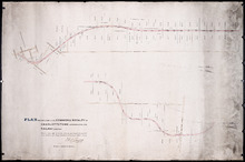
Plan Shewing Lands in the Common and Royalty of Charlottetown appropriated for Railway purposes.
Description: Plan showing land in the Common and Royalty of Charlottetown appropriated for Railway purposes. The map shows lots, acreage, roads, cities and towns.
Province: Prince Edward Island
Type: cadastral maps
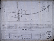
Plan of Proposed Railway Crossing North River to Mount Edward Roads
Description: Plan of proposed Railway crossing North River to Mount Edward Road. Department of Public Works and Highways, Province of Prince Edward Island. Plan shows 3 drawings consisting of the Railway &… more
Province: Prince Edward Island
Type: cadastral maps, transportation maps
Date Created: 1949
Unfinished plan of Alberton and Cascumpec Point, Lots 4 and 5
Description: Unfinished plan of Alberton and Cascumpec Point, Lots 4 and 5. Mainly outline. Shows churches, station ground, school, and the names of a few residents.
Province: Prince Edward Island
Type: cadastral maps
P.E.I. Railway Murray Harbour Branch : Plan Branch Line From Village Green to Vernon River Bridge
Description: Prince Edward Island Railway. Murray Harbour Branch. Plan of the branch line from Village Green to Vernon River Bridge (No.588). Plan produced by Wm. B. MacKenzie, Chief Engineer. The map shows lots… more
Province: Prince Edward Island
Type: cadastral maps
Date Created: 1906-05-28
Plan No 1 Office of the Registar of Deeds: Charlottetown P.E.Island
Description: Plan of land appropriated for the construction of the Murray Harbour Branch Railway through Queen's County (No.1). Plan produced by Wm. B. MacKenzie, Chief Engineer. The map shows residents,… more
Province: Prince Edward Island
Type: cadastral maps
Date Created: 1900-06-07
Plan of Cape Traverse Branch: Prince Edward Island Railway
Description: Canadian Government Railways, Prince Edward Island. Cape Traverse subdivision. Plans of the Railway right of way from Emerald Junction to Port Borden. Copied from the plans in the Engineer's… more
Province: Prince Edward Island
Type: cadastral maps
Plan of Railway appropriations in Lots 26, 27 and 28
Description: Plan of Railway appropriations in Lots 26, 27 and 28. The map shows lots, roads, residents, and acreage.
Province: Prince Edward Island
Type: cadastral maps, transportation maps
P.E.I. Railway: Elmira Branch Plan of Right-of-Way
Description: Prince Edward Island Railway. Elmira Branch. Plan of Right-of-Way (No.429, Kings Co.). Plan created by Wm. B. MacKenzie, Chief Engineer. The map shows lots, roads, residents, and acreage.
Province: Prince Edward Island
Type: cadastral maps
Date Created: 1909-06-02

Plan of Part of the Railway Line on Lots No 17.
Description: Plan of part of the Railway Line on Lot 17. Appropriations from the French Purchase to the Linkletter Road. The map shows roads, residents and acreage.
Province: Prince Edward Island
Type: cadastral maps, transportation maps
Date Created: 1872-04-29
Railway appropriations from Hunter River to Clyde Station: Lots 22 and 23
Description: Railway appropriations from Hunter River to Clyde Station. Lots 22 and 23. The map shows residents and acreage, roads, stations, ponds, and foliage.
Province: Prince Edward Island
Type: cadastral maps
Date Created: 1872
Plan-showing the Right of Way : Cape Traverse Branch P.E.I
Description: Plan showing the right of way of the Cape Traverse Branch of the Prince Edward Island Railway. The map shows roads, residents and acreage.
Province: Prince Edward Island
Type: cadastral maps

Plan Alterations of Railway on Lot 17 and Station Grounds at Summerside.
Description: Plan of Alterations of the Railway on Lot 17 and the Station Grounds at Summerside. The map shows lots, residents, streets, wharfs, and buildings.
Province: Prince Edward Island
Type: cadastral maps
Date Created: 1872-10-10
Plan of land appropriated by the Railway Commissioners in Lots 38 and 51
Description: Prince Edward Island Railway. Plan shows the land appropriated by the Railway Commissioners in Lots 38 and 51. The rail line is drawn in pink. Roads are shown in a lighter colour. Names of residents… more
Province: Prince Edward Island
Type: engineering maps
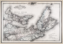
New Railway and Postal Map of the Dominion of Canada, Sheet No. 2
Description: Framed map shows the post offices, money order offices, P.O. saving offices, telegraph sections, ports of entry, railways and the distance between towns over post roads of the time. Prince Edward… more
Province: Prince Edward Island
Type: geological maps
Date Created: 1880
P.E.I. Railway Murray Harbour Branch: Plan of Spur Line and Ballast Pit at Surrey
Description: Prince Edward Island Railway. Murray Harbour Branch. Plan of Spur Line and Ballast Pit at Surrey (No.1159). Plan produced by H. Laurence, Engineer in Charge. Shown are roads, the railway, lots, and… more
Province: Prince Edward Island
Type: cadastral maps
Date Created: 1908-12-02

Plan of Part of Railway Line on Lot No. 16
Description: Plan of part of the Railway Line on Lot 16. The map shows roads, lots, water, and residents.
Province: Prince Edward Island
Type: cadastral maps
Date Created: 1872-04-30

Prince Edward Island Railway Plan showing right of way of the Murray Harbour Branch through Queen…
Description: Prince Edward Island Railway Plan showing right of way of the Murray Harbour Branch through Queen's County from Village Green to Pisquid Road. (Plan No.6) The map shows lots, residents, railway… more
Province: Prince Edward Island
Type: cadastral maps
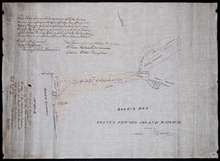
Prince Edward Island Railway
Description: Prince Edward Island Railway. Land appropriated at Souris. This plan shewing the lands appropriated by the Railway Commissioners is filed in the Office of Registar of Deeds and Keeper of Plans for… more
Province: Prince Edward Island
Type: cadastral maps
Date Created: 1874
Plan showing land at Souris appropriated for the Railway : Plan signed by O. Curtis, Registrar of…
Description: Plan showing land at Souris appropriated for the Railway. Plan signed by O. Curtis, Registrar of Deeds. Shown are residents, and railroad tracks.
Province: Prince Edward Island
Type: cadastral maps
Date Created: 1879-06-18
Plan of part of the Railway appropriation in Lots 5 and 6
Description: Plan of part of the Railway appropriation in Lots 5 and 6. Shown are lots, roads, and residents.
Province: Prince Edward Island
Type: cadastral maps, transportation maps
Prince Edward Island Railway Murray Harbour Branch: Plan of extension from Murray River to Murray…
Description: Prince Edward Island Railway. Murray Harbour Branch. Plan of extension from Murray River to Murray Harbour. Produced by Wm. B. MacKenzie, Chief Engineer. The map shows lots, residents, acreage and… more
Province: Prince Edward Island
Type: cadastral maps
Date Created: 1906-05-31
This Plan shewong the land appropriated by the Railway Commissioners is filed in th Office of the…
Description: Prince Edward Island Railway. Railway appropriation at St. Peter's Bay. (No.5) (Also, No. 238A). The map shows lots, roads, residents, and St. Peter's Bay. more
Province: Prince Edward Island
Type: cadastral maps
Date Created: 1874

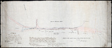
Tracing of the right of way for the Prince Edward Island Railway into Georgetown.
Description: Tracing of the right of way for the Prince Edward Island Railway into Georgetown.
Province: Prince Edward Island
Type: cadastral maps