IslandImagined
Historic Maps of PEI
Menu
Main navigation
Search
Map Archive
Map Archive sub-navigation
All Maps
... by County
Prince
Queens
Kings
... by Type
Boundary Maps
Cadastral Maps
Chorographic Maps
Fire Insurance Maps
Historical Atlases
Plans
Topographic Maps
Atlases
Cummins Atlas - 1928
Roe Brothers Atlas - 1878
Meacham's Atlas - 1880
Interactive
Interactive sub-navigation
Map Timeline
GeoPEI Map Viewer
Learn More
Learn More sub-navigation
FAQ
Learning Guides
Articles
Online Books
Glossary
Contact
Breadcrumb
Home
Search Content
Displaying 1 - 1 of 1
Results per page
27
54
108
Sort
Relevance ↓
Relevance ↑
Title ↓
Title ↑
Year ↓
Year ↑
Displaying 1 - 1 of 1
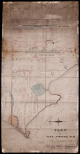
Plan of Part Township No. 28: The property of Henry Palmer Esquire
Description:
Plan of part of Lot 28 (No.75). The property of Henry Palmer. Shows names of residents, acreage , and land conveyance references, bodies of water such as marshes, straits, and rivers, roads,…
more
Province:
Prince Edward Island
Type:
cadastral maps