Displaying 1 - 2 of 2
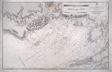
Hillsborough Bay
Description: Paper map in frame. Nautical chart originally published in 1842 and corrected and reissued many times. Large corrections in 1860, 1868, 1869, 1881. Relief is described pictorially, with hachures,… more
Publisher: Office of the Admiralty
Province: Prince Edward Island
Type: nautical charts
Date Issued: 1929
Date Created: 1842
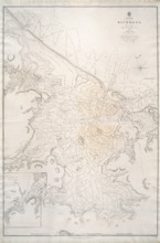
Richmond Bay: 1845
Description: Paper map in frame. Nautical chart originally published in 1845. Relief is described pictorially, with hachures, stippling and soundings. Bays, capes, heads, harbours, islands, lakes, ports, points,… more
Publisher: Hydrographic Office of the Admiralty
Province: Prince Edward Island
Type: nautical charts
Date Issued: 1850
Date Created: 1845