IslandImagined
Historic Maps of PEI
Menu
Main navigation
Search
Map Archive
Map Archive sub-navigation
All Maps
... by County
Prince
Queens
Kings
... by Type
Boundary Maps
Cadastral Maps
Chorographic Maps
Fire Insurance Maps
Historical Atlases
Plans
Topographic Maps
Atlases
Cummins Atlas - 1928
Roe Brothers Atlas - 1878
Meacham's Atlas - 1880
Interactive
Interactive sub-navigation
Map Timeline
GeoPEI Map Viewer
Learn More
Learn More sub-navigation
FAQ
Learning Guides
Articles
Online Books
Glossary
Contact
Breadcrumb
Home
Search Content
Displaying 1 - 1 of 1
Results per page
27
54
108
Sort
Relevance ↓
Relevance ↑
Title ↓
Title ↑
Year ↓
Year ↑
Displaying 1 - 1 of 1
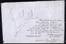
Plan of the division line between Lots 59 and 61, surveyed under the provisions of the Boundary…
Description:
Plan of the division line between Lots 59 and 61, surveyed under the provisions of the Boundary Bill 4 William 4 Cap.15. This copy is taken from an original plan created 15 August 1838 by surveyor…
more
Province:
Prince Edward Island
Type:
cadastral maps
Date Created:
1838-08-15
Date Modified:
1908-02