Displaying 1 - 2 of 2

Illustrated historical atlas of the province of Prince Edward Island: From surveys made under the…
Description: Published in 1880 by the J. H. Meacham Company, the Illustrated Historical Atlas of the Province of Prince Edward Island contains maps of each Lot on the Island, maps of Charlottetown and various… more
Publisher: J. H. Meacham & company
Type: historical atlases, pictorial maps
Date Issued: 1880
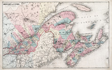
Dominion of Canada: (Eastern Sheet)
Description: Map showing the province of Quebec, New Brunswick, Nova Scotia, and Prince Edward Island. Shows rivers, lakes, channels, bays, roads, railroads, cities, and towns. The provinces and cities are tinted… more
Publisher: J. H. Meacham & company
Province: Quebec, New Brunswick, Nova Scotia, Prince Edward Island
Type: pictorial maps
Date Issued (Source): 1880