Displaying 109 - 135 of 154
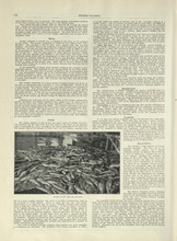
British Columbia - 2
Description: Text provides information of the population and the various industries in British Columbia, such as mining, fishing, manufacturing, and transportation.
Publisher: Cummins Map Co.
Province: British Columbia
Type: text
Date Issued (Source): 1927
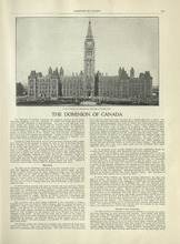
The Dominion of Canada - 1
Description: Text provides information of the history of Canada as a dominion and the establishment of the provinces and territories.
Publisher: Cummins Map Co.
Type: text
Date Issued (Source): 1927
The Dominion of Canada - 2
Description: Text provides information of the physical features of the land dividing each provinces and territories, and the industries that belong to each province and territory
Publisher: Cummins Map Co.
Province: Yukon, Northwest Territories
Type: text
Date Issued (Source): 1927
Title Page - International Atlas
Description: The title page for the New International Atlas of the World
Publisher: Cummins Map Co.
Type: text
Date Issued (Source): 1927
Table of Contents - International Atlas
Description: The table of contents page that shows the list of countries and maps of countries and the page they are mentioned
Publisher: Cummins Map Co.
Type: text
Date Issued (Source): 1927
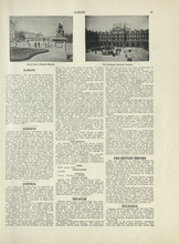
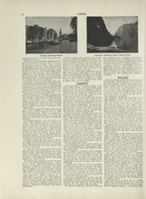
Europe - 1
Description: Text provides an introduction to Europe and gives the general history, population, climate, and notable industries of Austria, Belgium, the British Empire, and Bulgaria
Publisher: Cummins Map Co.
Type: text
Date Issued (Source): 1927
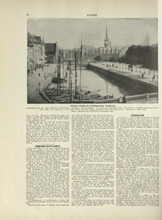
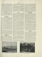
Europe - 2
Description: Text provides information on the general history, population, climate, and notable industries of Czecho-Slovakia and Denmark
Publisher: Cummins Map Co.
Type: text
Date Issued (Source): 1927
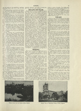
Europe - 3
Description: Text provides information on the general history, population, climate, and notable industries of England, Wales, Esthonia, and Finland
Publisher: Cummins Map Co.
Type: text
Date Issued (Source): 1927
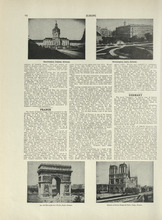
Europe - 4
Description: Text provides information on the general history, population, climate, and notable industries of France and Germany
Publisher: Cummins Map Co.
Type: text
Date Issued (Source): 1927
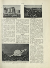
Europe - 5
Description: Text provides information on the general history, population, climate, and notable industries of Greece and Hungary
Publisher: Cummins Map Co.
Type: text
Date Issued (Source): 1927
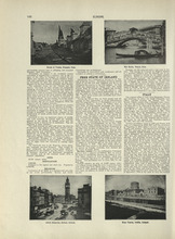
Europe - 6
Description: Text provides information on the general history, population, climate, and notable industries of Free State of Ireland, and Italy
Publisher: Cummins Map Co.
Type: text
Date Issued (Source): 1927
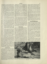
Europe - 7
Description: Text provides information on the general history, population, climate, and notable industries of Jugo-Slavia, Lithuania, and the Netherlands
Publisher: Cummins Map Co.
Type: text
Date Issued (Source): 1927
Europe - 8
Description: Text provides information on the general history, population, climate, and notable industries of Norway and Poland
Publisher: Cummins Map Co.
Type: text
Date Issued (Source): 1927
Europe - 9
Description: Text provides information on the general history, population, climate, and notable industries of Portugal, Romania, Russia, Scotland, and Spain
Publisher: Cummins Map Co.
Type: text
Date Issued (Source): 1927

Europe - 10
Description: Text provides information on the general history, population, climate, and notable industries of Sweden, Switzerland, Ukraine, and the Minor European States (Andorra, the Channel Islands, Crete,… more
Publisher: Cummins Map Co.
Type: text
Date Issued (Source): 1927
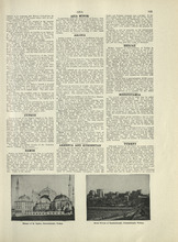
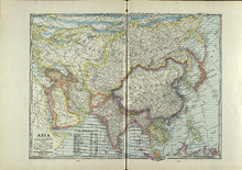
Asia - 1
Description: Text provides information on the general history, population, climate, and notable industries of Cyprus, Samos, Arabia, Armenia and Kurdestan, Hedjaz, Mesopotamia, and Turkey
Publisher: Cummins Map Co.
Type: text
Date Issued (Source): 1927
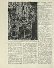
Asia - 3
Description: Text provides information on the general history, population, climate, and notable industries of Afghanistan and Persia.
Publisher: Cummins Map Co.
Type: text
Date Issued (Source): 1927
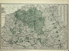
Western Battle Front
Description: The map shows the Western Battle Front in France, Belgium, and Germany. Shown are fortresses and fortified towns, forts, airship bases, wireless stations, railways, highways, and canals.
Publisher: Cummins Map Co.
Type: cadastral maps
Date Issued (Source): 1927
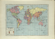
The World: Showing Principal Nations' Colonial Possessions
Description: The map shows the world and colonial possessions. Shown is a coloured table of the principal Nations' Colonial Possessions, countries, oceans and coordinates. more
Publisher: Cummins Map Co.
Type: cadastral maps
Date Issued (Source): 1927
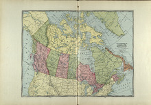
The Dominion of Canada and Newfoundland
Description: The map shows the dominion of Canada and Newfoundland. Shown are all provinces, territories, Greenland, and United States, oceans, bays, and mountains.
Publisher: Cummins Map Co.
Type: cadastral maps
Date Issued (Source): 1927
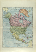
North America
Description: The map shows North America. Shown is the dominion of Canada, United States, Mexico, Central America, bodies of water, and coordinates.
Publisher: Cummins Map Co.
Type: cadastral maps
Date Issued (Source): 1927
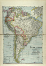
South America
Description: The map shows South America. Shown is a table of Political Divisions of South America with area and population, capitals of countries and states, railroads and telegraph lines, bodies of water,… more
Publisher: Cummins Map Co.
Type: cadastral maps
Date Issued (Source): 1927
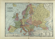
Europe
Description: The map shows the country of Eroupe. Shown are capitals of countries, railroads, submarine telegraph lines, a table of Principal Divisions of Europe, bodies of water, and coordinates.
Publisher: Cummins Map Co.
Type: cadastral maps
Date Issued (Source): 1927
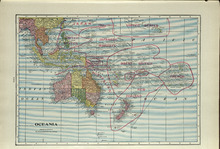
Oceania
Description: The map shows the Oceania. Shown are the Topic of Capricorn and the Equator lines, countries, great sand deserts, bodies of water, cities, and towns.
Publisher: Cummins Map Co.
Type: cadastral maps
Date Issued (Source): 1927