Displaying 82 - 108 of 154
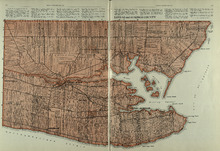
Lots 63 and 64: Kings County
Description: The map shows lots 63 and 64 in Kings county. Shown are Northumberland Strait, Gulf of St. Lawrence, Murray Harbour, Island and River, points, Herring Ponds, landowners, acreage, roads, and railroads.
Publisher: Cummins Map Co.
Province: Prince Edward Island
Type: cadastral maps
Date Issued (Source): 1927
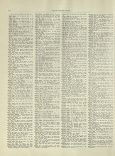
Rural Directory - Lots 63 and 64, Kings County
Description: A directory listing of residents of lots 63 and 64
Publisher: Cummins Map Co.
Province: Prince Edward Island
Type: text
Date Issued (Source): 1927
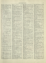
Rural Directory - Lots 63 and 64, Kings County
Description: A directory listing of residents of lots 63 and 64.
Publisher: Cummins Map Co.
Province: Prince Edward Island
Type: text
Date Issued (Source): 1927
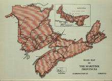
Road Map of the Maritime Provinces
Description: The map shows the Provinces of Prince Edward Island, New Brunswick, Nova Scotia, and Cape Breton Island. Also shown are cities and towns and a Reference table that shows different road conditions.
Publisher: Cummins Map Co.
Province: Prince Edward Island, New Brunswick, Nova Scotia, Cape Breton Island
Type: transportation maps
Date Issued (Source): 1927
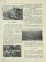
Nova Scotia - 1
Description: Text provides information of the history and industries in Nova Scotia
Publisher: Cummins Map Co.
Province: Nova Scotia
Type: text
Date Issued (Source): 1927
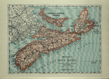
Province of Novia Scotia and Prince Edward Island Canada
Description: The map shows the Provinces of Novia Scotia and Prince Edward Island Canada. Shown are Cape Breton Island, New Brunswick, Atlantic Ocean, Sable Island, Northumberland Strait, Bay of Fundy, roads,… more
Publisher: Cummins Map Co.
Province: Nova Scotia, Prince Edward Island, Cape Breton Island, New Brunswick
Type: cadastral maps
Date Issued (Source): 1927
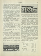
Nova Scotia - 2
Description: Text provides information of the different industries of Nova Scotia such as mining, coal, foresty and agriculture
Publisher: Cummins Map Co.
Province: Nova Scotia
Type: text
Date Issued (Source): 1927
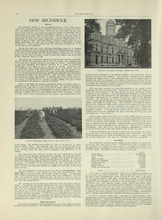
New Brunswick - 1
Description: Text provides information of history, government, and agriculture of New Brunswick.
Publisher: Cummins Map Co.
Province: New Brunswick
Type: text
Date Issued (Source): 1927
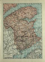
Province of New Brunswick and part of Quebec, Canada
Description: The map shows the Provinces of New Brunswick and part of Quebec, Canada. Shown are Prince Edward Island, United States, Nova Scotia, St. Lawrence River and Gulf, Northumberland Strait, Bay of Fundy,… more
Publisher: Cummins Map Co.
Province: Nova Scotia, Prince Edward Island, Quebec, New Brunswick
Type: cadastral maps
Date Issued (Source): 1927
New Brunswick - 2
Description: Text provides information of Farming and Forestry in New Brunswick
Publisher: Cummins Map Co.
Province: New Brunswick
Type: text
Date Issued (Source): 1927
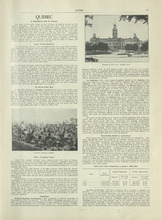
Quebec - 1
Description: Text provides information of history, population, and farming industry of Quebec
Publisher: Cummins Map Co.
Province: Quebec
Type: text
Date Issued (Source): 1927
Province of Quebec, Canada
Description: The map shows the province of Quebec in Canada. Shown are Ontario, New York, Maine, towns, cities, raods, railroads, and St. Lawrence River.
Publisher: Cummins Map Co.
Province: Quebec
Type: cadastral maps
Date Issued (Source): 1927
Quebec - 2
Description: Text provides information of the farming industry of Quebec
Publisher: Cummins Map Co.
Province: Quebec
Type: text
Date Issued (Source): 1927
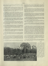
Ontario - 1
Description: Text provides information on the history and farming industries of Ontario
Publisher: Cummins Map Co.
Province: Ontario
Type: text
Date Issued (Source): 1927
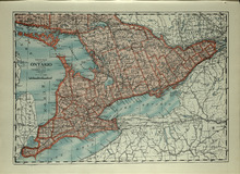
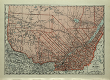
Province of Ontario, Canada
Description: The map shows the Province of Ontario, Canada. Shown are Georgian Bay, Lake Ontario, Erie, and Huron, Michigan, New York, roads, towns and cities.
Publisher: Cummins Map Co.
Province: Ontario
Type: cadastral maps
Date Issued (Source): 1927

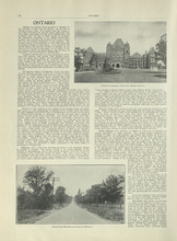
Ontario - 2
Description: Text provides information of the farming and other industries of Ontario
Publisher: Cummins Map Co.
Province: Ontario
Type: text
Date Issued (Source): 1927
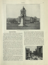
Manitoba - 1
Description: Text provides information of history, climate, and farming in Manitoba.
Publisher: Cummins Map Co.
Province: Manitoba
Type: text
Date Issued (Source): 1927
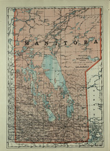
Province of Manitoba, Canada
Description: The map shows the province of Manitoba, Canada. Shown are the lakes, rivers and other bodies of water, and railroads.
Publisher: Cummins Map Co.
Province: Manitoba, Saskatchewan, Ontario
Type: cadastral maps
Date Issued (Source): 1927
Manitoba - 2
Description: Text provides information of the landscape, industries, and government of Manitoba
Publisher: Cummins Map Co.
Province: Manitoba
Type: text
Date Issued (Source): 1927
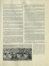
Saskatchewan - 1
Description: Text provides information of the history, government, and landscape of Saskatchewan
Publisher: Cummins Map Co.
Province: Saskatchewan
Type: text
Date Issued (Source): 1927
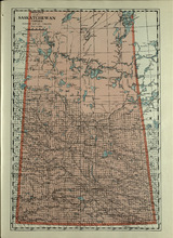
Province of Saskatchewan, Canada
Description: The map shows the province of Saskatchewan, Canada. Shown are rivers, lakes, and other bodies of water, roads, and railroads.
Publisher: Cummins Map Co.
Province: Saskatchewan, Alberta, Mantitoba
Type: cadastral maps
Date Issued (Source): 1927
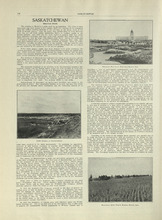
Saskatchewan - 2
Description: Text provides information of population, land, climate, and farming in Saskatchewan
Publisher: Cummins Map Co.
Province: Saskatchewan
Type: text
Date Issued (Source): 1927
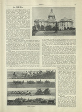
Alberta - 1
Description: Text provides information of different regions of Alberta, their history, and agriculture in Alberta
Publisher: Cummins Map Co.
Province: Alberta
Type: text
Date Issued (Source): 1927
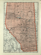
Province of Alberta, Canada
Description: The map shows the province of Alberta, Canada. Shown are bodies of water, rivers, lakes, etc., cities and towns, roads and railroads.
Publisher: Cummins Map Co.
Province: Alberta, British Columbia, Saskatchewan
Type: cadastral maps
Date Issued (Source): 1927
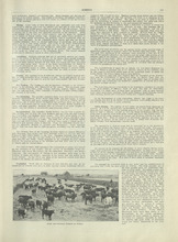
Alberta - 2
Description: Text provides information of different industries in Alberta, and the population in Alberta
Publisher: Cummins Map Co.
Province: Alberta
Type: text
Date Issued (Source): 1927
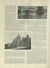
British Columbia - 1
Description: Text provides information of history, climate, lumbering, and agriculture in British Columbia
Publisher: Cummins Map Co.
Province: British Columbia
Type: text
Date Issued (Source): 1927
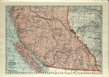
Province of British Columbia, Canada
Description: The map shows the province of British Columbia, Canada. Shown are the Pacific Ocean, Rocky Mountains, Vancouver Island, mountains, roads, and railroads.
Publisher: Cummins Map Co.
Province: British Columbia, Alberta
Type: cadastral maps
Date Issued (Source): 1927