Displaying 55 - 81 of 154
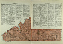
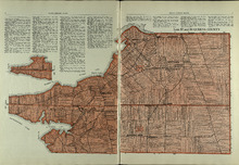
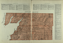
Lot 48: Queens County
Description: The map shows lot 48 in Queens county. Shown are Hillsborough River, Fullerton Creek, railroads, roads, landowners, and acreage.
Publisher: Cummins Map Co.
Province: Prince Edward Island
Type: cadastral maps
Date Issued (Source): 1927
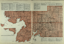
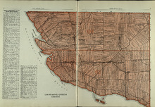
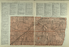
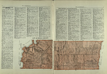
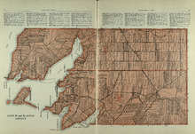
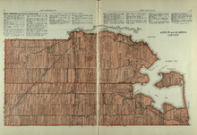
Lots 49 and 50: Queens County
Description: The map shows lots 49 and 50 in Queens county. Shown are bays, Governor Island, points, rivers, roads, railroads, landowners, and acreage.
Publisher: Cummins Map Co.
Province: Prince Edward Island
Type: cadastral maps
Date Issued (Source): 1927
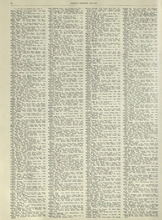
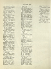
Rural Directory - Lots 49 and 50, Queens County
Description: A directory listing of residents of lots 49 and 50.
Publisher: Cummins Map Co.
Province: Prince Edward Island
Type: text
Date Issued (Source): 1927
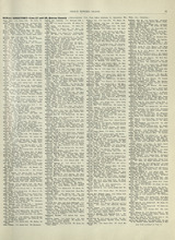
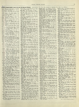
Rural Directory - Lots 57 and 58, Queens County
Description: A directory listing of residents of lots 57 and 58.
Publisher: Cummins Map Co.
Province: Prince Edward Island
Type: text
Date Issued (Source): 1927
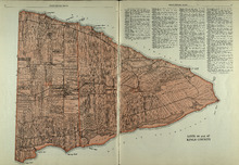
Lots 57 and 58: Queens County
Description: The map shows lots 57 and 58 in Queens county. Shown are Pinette Harbour, Northumberland Strait, Orwell Bay, rivers, roads, railroads, landowners,and acreage.
Publisher: Cummins Map Co.
Province: Prince Edward Island
Type: cadastral maps
Date Issued (Source): 1927
Lots 60 and 62: Queens County
Description: The map shows lots 60 and 62 in Queens county. Shown are the Northumberland Strait, roads, railroads, harbour, points, landowners, and acreage.
Publisher: Cummins Map Co.
Province: Prince Edward Island
Type: cadastral maps
Date Issued (Source): 1927
Rural Directory - Lots 60 and 62, Queens County
Description: A directory listing of residents of lots 60 and 62.
Publisher: Cummins Map Co.
Province: Prince Edward Island
Type: text
Date Issued (Source): 1927
Rural Directory - Lots 35 and 36, Queens County
Description: A directory listing of residents of lots 35 and 36.
Publisher: Cummins Map Co.
Province: Prince Edward Island
Type: text
Date Issued (Source): 1927
Lots 35 and 36: Queens County
Description: The map shows lots 35 and 36 in Queens County. Shown are Hillsborough River, Tracadie Bay, Gulf of St. Lawrence. Mill Cove, landowners, acreage, raods, and railroads.
Publisher: Cummins Map Co.
Province: Prince Edward Island
Type: cadastral maps
Date Issued (Source): 1927
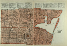
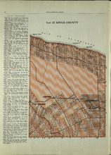
Lot 37, Queens County: Lot 38 Kings County
Description: The map shows lot 37 in Queens county and lot 38 in Kings county. Shown are the Gulf of St. Lawrence, Savage Harbour, landowners, acreage, roads, railroads, and rivers.
Publisher: Cummins Map Co.
Province: Prince Edward Island
Type: cadastral maps
Date Issued (Source): 1927
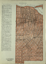
Lot 39: Kings County
Description: The map shows lot 39 in Kings county. Shown are the Gulf of St. Lawrence, St. Peters bay, landowners, acreage, roads, railroads, Stukeley Ponds, and sands hills.
Publisher: Cummins Map Co.
Province: Prince Edward Island
Type: cadastral maps
Date Issued (Source): 1927
Lots 40 and 41: Kings County
Description: The map shows lots 40 and 41 in Kings county. Shown are the Gulf of St. Lawrence, St. Peters Bay, landowners, acreage, roads, and railroads.
Publisher: Cummins Map Co.
Province: Prince Edward Island
Type: cadastral maps
Date Issued (Source): 1927
Lot 42: Kings County
Description: The map shows lot 42 in Kings county. Shown are the Gulf of St. Lawrence, points, landowners, acreage, roads, and railroads.
Publisher: Cummins Map Co.
Province: Prince Edward Island
Type: cadastral maps
Date Issued (Source): 1927
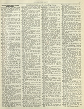
Rural Directory - Lots 42 - 44, Kings County
Description: A directory listing of residents of lots 42, 43, and 44
Publisher: Cummins Map Co.
Province: Prince Edward Island
Type: text
Date Issued (Source): 1927
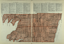
Lots 43 and 44 : Kings County
Description: The map shows lots 43 and 44 in Kings county. Shown are the Gulf of St. Lawrence, bays, points, rivers, landowners, acreage, roads, and railroads.
Publisher: Cummins Map Co.
Province: Prince Edward Island
Type: cadastral maps
Date Issued (Source): 1927
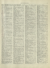
Rural Directory - Lot 51, 52, and 66, Kings County
Description: A directory listing of residents of lot 51, 52, and 66
Publisher: Cummins Map Co.
Province: Prince Edward Island
Type: text
Date Issued (Source): 1927
Lot 45: Kings County
Description: The map shows lot 45 in Kings county. Shown are the Gulf of St. Lawrence, Colville bay, landowners, acreage, roads, and railroads.
Publisher: Cummins Map Co.
Province: Prince Edward Island
Type: cadastral maps
Date Issued (Source): 1927
Lots 46 and 47 : Kings County
Description: The map shows lots 46 and 47 in Kings county. Shown are the Gulf of St. Lawrence, points, rivers, coves, landowners, acreage, roads, railroads, lakes, and sand.
Publisher: Cummins Map Co.
Province: Prince Edward Island
Type: cadastral maps
Date Issued (Source): 1927
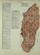
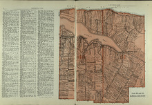
Georgetown Royalty: Kings County
Description: The map shows Georgetown Royalty in Kings county. Shown are landowners, acreage, Brudenell and Cardigan River, Albion Bay, roads, and railroads.
Publisher: Cummins Map Co.
Province: Prince Edward Island
Type: cadastral maps
Date Issued (Source): 1927
Lots 51, 52, and 66: Kings County
Description: The map shows lots 51, 52, and 66 in Kings County. Shown are Brown Creek, Montague River, Landowners, acreage, roads, and railroads.
Publisher: Cummins Map Co.
Province: Prince Edward Island
Type: cadastral maps
Date Issued (Source): 1927
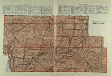
Lots 53 and 54: Kings County
Description: The map shows lots 53 and 54 in Kings county. Shown are bays, rivers, an Indian marsh, landowners, acreage, roads, and railroads.
Publisher: Cummins Map Co.
Province: Prince Edward Island
Date Issued (Source): 1927
Rural Directory - Lots 53 and 54, Kings County
Description: A directory listing of residents of lots 53 and 54.
Publisher: Cummins Map Co.
Province: Prince Edward Island
Type: text
Date Issued (Source): 1927
Rural Directory - Lots 55 and 56, Kings County
Description: A directory listing of residents of lots 55 and 56
Publisher: Cummins Map Co.
Province: Prince Edward Island
Type: text
Date Issued (Source): 1927
Lots 55 and 56: Kings County
Description: The map shows lots 55 and 56 in Kings county. Shown are bays, rivers, ponds, landowners, acreage, roads, coves, and Boughton Island.
Publisher: Cummins Map Co.
Province: Prince Edward Island
Type: cadastral maps
Date Issued (Source): 1927
Lots 59 and 61: Kings County
Description: The map shows lots 59 and 61 in Kings county. Shown are Montague river, bays, points, coves, landowners, acreage, roads, creeks, and Panamure Island.
Publisher: Cummins Map Co.
Province: Prince Edward Island
Type: cadastral maps
Date Issued (Source): 1927
Rural Directory - Lots 59 and 61, Kings County
Description: A directory listing of residents of lots 59 and 61.
Publisher: Cummins Map Co.
Province: Prince Edward Island
Type: text
Date Issued (Source): 1927
Rural Directory - Lots 59, 61, 63, and 64, Kings County
Description: A directory listing of residents of lots 59 , 61, 63, and 64
Publisher: Cummins Map Co.
Province: Prince Edward Island
Type: text
Date Issued (Source): 1927