Displaying 1 - 2 of 2
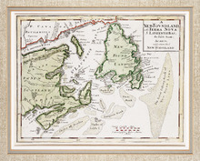
A NewFoundland, od. Terra Nova S. Laurentii Bay, die Fisch-Bank, Acadia, nebst einem Theil New…
Description: The map shows the Gulf of St. Lawrence, part of the northeast Atlantic and the provinces of New Brunswick, Newfoundland, Nova Scotia and Prince Edward Island, as well as part of Quebec. Sable Island… more
Province: New Brunswick, Newfoundland, Nova Scotia, Prince Edward Island, Quebec
Type: topographic maps
Date Created: 1720

L'ACADIE: Par le Sr. Robert de Vaugindy Fils de Mr. Robert Geogr. ord, du Roy, Avec Privilege
Description: Period designation 18th century. The map shows bodies of water such as Baye Francoise, villages, towns, cities, mountains, trees, islands, and banks.
Province: Nova Scotia, Prince Edward Island
Type: topographic maps
Date Created: Unknown year in the century of the 1700s