Displaying 1 - 3 of 3

Plan of Township No. 4: Compiled from the plans, leases, deeds, and other documents on file in the…
Description: The map shows Lot 4 divided into parcels of land with the names of residents, their acreage amounts and land conveyance references. The map shows roads in a light brown colour. It shows the P.E.I.… more
Province: Prince Edward Island
Type: cadastral maps
Date Created: 1911-06

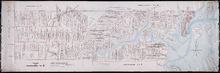
Plan of Township No. 5: compiled from plans, leases, deeds, and other documents on file in the Land…
Description: Plan of Lot 5 compiled from plans, leases, deeds, and other documents on file in the Land Office. The map shows Lot 5 divided into parcels of land with names of residents, their acreage amounts and… more
Province: Prince Edward Island
Type: cadastral maps
Date Created: 1911-09