Displaying 1 - 2 of 2
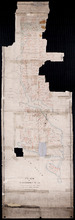
Plan of Township No. 55: From various Surveys made between the Years 1818 and 1845
Description: The map is a Plan of Township No. 55. The mqp shows bodies of water such as the Cardigan River, and Boughton River, lots, landowers, acreage, and Boughton Island.
Province: Prince Edward Island
Type: cadastral maps
Date Created: 1848-03-21
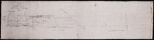
Plan of Part of the Estate of R.B. Stewart Esq. Situate on Lot or Township No. 27 shewing the…
Description: Plan of part of Lot 27. Estate of R.B. Stewart. Shows names of residents, acreage, and a few land conveyance references, roads, and the sea shore.
Province: Prince Edward Island
Type: cadastral maps
Date Created: 1848-03-24