Displaying 1 - 5 of 5

Geological Maps of the Maritime Province: of the Dominion of Canada
Description: The map shows the geology of the Maritime Province. Shown are provinces of New Brunswick, Nova Scoita and Cape Breton Island, Prince Edward Island, and Newfoundland as an insert. Other objects shown… more
Publisher: Roe Brothers
Province: Prince Edward Island, New Brunswick, Nova Scotia, Cape Breton Island
Type: geological maps
Date Issued (Source): 1878
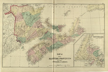
Map of the Maritime Provinces: of the Dominion of Canada
Description: The map shows the geology of the Maritime Province. Shown are provinces of New Brunswick, Nova Scoita and Cape Breton Island, Prince Edward Island, and Newfoundland as an insert. Other objects shown… more
Publisher: Roe Brothers
Province: Prince Edward Island, New Brunswick, Nova Scotia, Cape Breton Island
Type: geological maps
Date Issued (Source): 1878
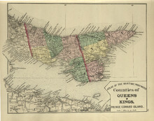
Counties of Queens and Kings: Prince Edward Island
Description: The map shows the counties of Queens and Kings in Prince Edward Island. Shown are bays, points, rivers, capes, coves, harbours, roads, railroads, cities, and towns.
Publisher: Roe Brothers
Province: Prince Edward Island
Type: geological maps
Date Issued (Source): 1878
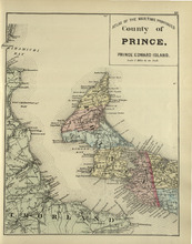
County of Prince: Prince Edward Island
Description: The map shows the county of Prince in Prince Edward Island. Shown are capes, bays, coves, roads, railroads, cities and towns.
Publisher: Roe Brothers
Province: Prince Edward Island
Type: geological maps
Date Issued (Source): 1878
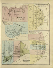
Chatham : Charlottetown : New Castle : City of Fredricton : Moncton: Northumberland Co. N.B..…
Description: The map shows Catham in the Northumberland county. New Brunswick. Shown are a river, wharf, streets, buildings, lots and a ferry crossing. The map shows Charlottetown in Queens county, Prince Edward… more
Publisher: Roe Brothers
Province: New Brunswick, Prince Edward Island
Type: geographical maps
Date Issued (Source): 1878