Displaying 1 - 1 of 1
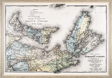
New Atlas of the Dominion of Canada — Counties of Cumberland, Colchester, Pictou, Antigonish,…
Description: The map shows Prince Edward Island and part of Nova Scotia, including all of Cape Breton. The provinces' counties are coloured and labelled in uppercase lettering. A legend explains the symbols… more
Publisher: Meacham Publishing Co.
Province: Nova Scotia, Prince Edward Island
Type: topographic maps
Date Created: 1875 (year approximate)