Displaying 1 - 2 of 2
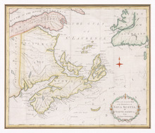
A New and Accurate Map of the Province of Nova Scotia, in North America, From the Latest…
Description: Framed map of the province of Nova Scotia and vicinity. The map shows bodies of water such as the Gulf of St. Lawrence and Bay of Fundy, towns, cities, villages, islands, banks, and a compass rose.
Province: Nova Scotia
Type: topographic maps, pictorial maps
Date Created: 1773
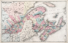
Dominion of Canada: (Eastern Sheet)
Description: Map showing the province of Quebec, New Brunswick, Nova Scotia, and Prince Edward Island. Shows rivers, lakes, channels, bays, roads, railroads, cities, and towns. The provinces and cities are tinted… more
Publisher: J. H. Meacham & company
Province: Quebec, New Brunswick, Nova Scotia, Prince Edward Island
Type: pictorial maps
Date Issued (Source): 1880