Displaying 1 - 16 of 16

Geological Map of Canada and Newfoundland: Derive from the Results of The Canadian Geological…
Description: Framed map of Canada and Newfoundland. The map is has colours for different land marks, and a table that explains it all. Shown are bodies of water such as rivers, islands, roads, towns, and cities.
Province: Newfoundland, New Brunswick, Prince Edward Island, Nova Scotia, Quebec
Type: geological maps
Date Created: 1866 (year uncertain)

Geological Maps of the Maritime Province: of the Dominion of Canada
Description: The map shows the geology of the Maritime Province. Shown are provinces of New Brunswick, Nova Scoita and Cape Breton Island, Prince Edward Island, and Newfoundland as an insert. Other objects shown… more
Publisher: Roe Brothers
Province: Prince Edward Island, New Brunswick, Nova Scotia, Cape Breton Island
Type: geological maps
Date Issued (Source): 1878
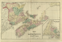
Map of the Maritime Provinces: of the Dominion of Canada
Description: The map shows the geology of the Maritime Province. Shown are provinces of New Brunswick, Nova Scoita and Cape Breton Island, Prince Edward Island, and Newfoundland as an insert. Other objects shown… more
Publisher: Roe Brothers
Province: Prince Edward Island, New Brunswick, Nova Scotia, Cape Breton Island
Type: geological maps
Date Issued (Source): 1878
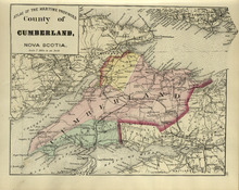
County of Cumberland: Nova Scotia
Description: The map shows the county of Cumberland in Nova Scotia. Shown are bays, channels, basins, mountains, rivers, railroads and stations, lakes, cities and towns.
Publisher: Roe Brothers
Province: Nova Scotia
Type: geological maps
Date Issued (Source): 1878
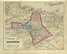
County of Colchester: Nova Scotia
Description: The map shows the county of Colchester in Nova Scotia. Shown are railroads and stations, basins, rivers, mountains, cities and towns.
Publisher: Roe Brothers
Province: Nova Scotia
Type: geological maps
Date Issued (Source): 1878
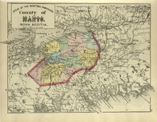
County of Hants: Nova Scotia
Description: The map shows the county of Hants in Nova Scotia. Shown are basins, lakes, gold mines, railroads, stations, and rivers.
Publisher: Roe Brothers
Province: Nova Scotia
Type: geological maps
Date Issued (Source): 1878
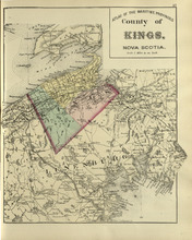
County of Kings: Nova Scotia
Description: The map shows the county of Kings in Nova Scotia. Shown are bays, brooks, creeks, lakes, railroads and stations, mines, roads, cities and towns.
Publisher: Roe Brothers
Province: Nova Scotia
Type: geological maps
Date Issued (Source): 1878
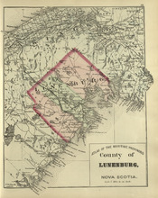
County of Lunenburg: Nova Scotia
Description: The map shows the county of Lunenburg in Nova Scotia. Shown are railroads abd stations, roads, rivers, bays, coves, basins, lakes, and harbours.
Publisher: Roe Brothers
Province: Nova Scotia
Type: geological maps
Date Issued (Source): 1878
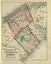
Coutnies of Annapolis and Queens : Nova Scotia
Description: The map shows the counties of Annapolis and Queens in Nova Scotia. Shown are rivers, roads, railroads, stations, lakes, harbours, cities, and towns.
Publisher: Roe Brothers
Province: Nova Scotia
Type: geological maps
Date Issued (Source): 1878
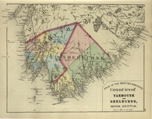
Counties of Yarmouth and Shelburne: Nova Scotia
Description: The map shows the counties of Yarmouth and Shelburne in Nova Scotia. Shown are railroads, stations, capes, coves, rivers, lakes, and harbours.
Publisher: Roe Brothers
Province: Nova Scotia
Type: geological maps
Date Issued (Source): 1878
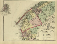
County of Digby: Nova Scotia
Description: The map shows the county of Digby in Nova Scotia. Shown are coves, rivers, capes, lakes, roads, railroads, bridges, cities and towns.
Publisher: Roe Brothers
Province: Nova Scotia
Type: geological maps
Date Issued (Source): 1878
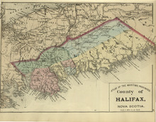
County of Halifax: Nova Scotia
Description: The map shows the county of Halifax in Nova Scotia. Shown are harbours, rivers, lakes, bays, gold mines, towns, and cities.
Publisher: Roe Brothers
Province: Nova Scotia
Type: geological maps
Date Issued (Source): 1878
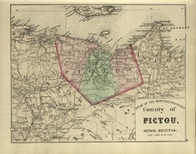
County of Pictou: Nova Scotia
Description: The map shows the county of Pictou in Nova Scotia. Shown are channel, rivers, lakes, harbours, railroads, lakes, mills, towns, and cities.
Publisher: Roe Brothers
Province: Nova Scotia
Type: geological maps
Date Issued (Source): 1878
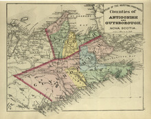
Couties of Antigonish and Guysborough: Nova Scotia
Description: The map shows the counties of Antigonish and Guysborough in Nova Scotia. Shown are rivers, bays, capes, lakes, points, roads, railroads, coves, harbours, cities, and towns.
Publisher: Roe Brothers
Province: Nova Scotia
Type: geological maps
Date Issued (Source): 1878
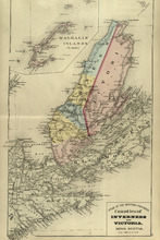
Counties of Inverness and Victoria: Nova Scotia
Description: The map shows the counties of Inverness and Victoria in Nova Scotia. Shown are bays, lakes, rivers, coves, gold mines, islands, harbours, cities, and towns.
Publisher: Roe Brothers
Province: Nova Scotia
Type: geological maps
Date Issued (Source): 1878
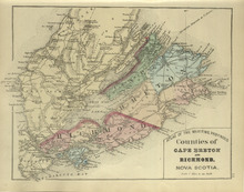
Counties of Cape Breton and Richmond: Nova Scotia>
Description: The map shows the counties of Cape Breton and Richmond in Nova Scotia. Shown are bays, lakes, points, channels, harbours, roads, railroads, towns, and cities.
Publisher: Roe Brothers
Province: Nova Scotia
Type: geological maps
Date Issued (Source): 1878