Displaying 1 - 4 of 4
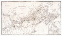
British possessions in North America from the Report of the Emigration Committee of 1827
Description: British possessions in North America, for the report of the Emigration Committee of 1827, corrected to 1834. Published by Longman & Co., London.
Publisher: Ashby, H., Longman & Co.
Province: New Brunswick, Nova Scotia, Prince Edward Island, Quebec, Maine, Vermont
Type: cadastral maps, topographic maps
Date Created: 1834

Plan de l'Ȋle de St. Jean au Nord de l'Acadie et dans le Sud du Golfe de St. Laurent.:…
Description: Plan de l'Ȋle de St. Jean. Par Ordre de M. de Sartine, Conseiller d'Etat, Ministre et Secretaire d'Etat au Département de la Marine. The map shows the province of Prince Edward Island… more
Publisher: Sartine, M. de
Province: Prince Edward Island
Type: topographic maps
Date Created: 1778
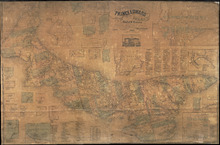
Topographical Map of Prince Edward Island in the Gulf of St. Lawrence
Description: Prince Edward Island divided into Counties and Parishes with the Lots as granted by Government, exhibiting all the New Settlements, Roads, Mills, etc. Published by H. Ashby, King Street, Cheapside,… more
Publisher: W. E. & H. H. Baker
Province: Prince Edward Island
Type: topographic maps, cadastral maps, pictorial maps
Date Created: 1863

Map of Prince Edward Island in the Gulf of St. Lawrence: for McGregor's British America
Publisher: Ballantyne and Company
Province: Prince Edward Island
Type: cadastral maps, topographic maps
Date Created: 1832