Displaying 1 - 2 of 2

Illustrated historical atlas of the province of Prince Edward Island: From surveys made under the…
Description: Published in 1880 by the J. H. Meacham Company, the Illustrated Historical Atlas of the Province of Prince Edward Island contains maps of each Lot on the Island, maps of Charlottetown and various… more
Publisher: J. H. Meacham & company
Type: historical atlases, pictorial maps
Date Issued: 1880
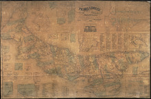
Topographical Map of Prince Edward Island in the Gulf of St. Lawrence
Description: Prince Edward Island divided into Counties and Parishes with the Lots as granted by Government, exhibiting all the New Settlements, Roads, Mills, etc. Published by H. Ashby, King Street, Cheapside,… more
Publisher: W. E. & H. H. Baker
Province: Prince Edward Island
Type: topographic maps, cadastral maps, pictorial maps
Date Created: 1863