Displaying 433 - 459 of 533
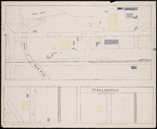
Wellington, Lot 16
Description: This item is a fire insurance plan of the community of Wellington. It shows the village in three (3) sections that are intended to be continuous. The largest map section, across the top of the sheet… more
Province: Prince Edward Island
Type: fire insurance maps
Date Issued (Source): 1888
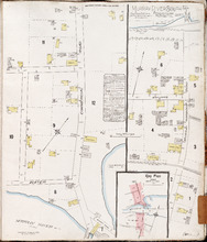
Murray River South P.E.I., Kings Co.: Population 300. No Protection. Oct 1910
Description: This is a fire insurance plan of the community of Murray River South that consists of two maps--one for each side of the Murray River. The larger map, on the left side of the page, shows an area of… more
Publisher: Chas. E. Goad, Civil Engineer
Province: Prince Edward Island
Type: fire insurance maps
Date Created: 1910-10
Date Issued (Source): 1888

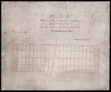
Plan of Lot 23
Description: Plan of Lot 23. Shows names of residents in central portion of Lot, i.e. around Clyde River.
Province: Prince Edward Island
Type: cadastral maps
Tracing from Plan of North part of P. E. Island surveyed by Captn. Bayfield
Description: Tracing from plan of North part of Prince Edward Island surveyed by Captain Bayfield. Tracing by H.J. Cundall. Outline of coast, Lots 1-11. (No.94). The map shows bodies of water such as Gulf Shore,… more
Province: Prince Edward Island
Type: cadastral maps

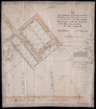
Plan of Building Lots in Common Lots Nos. 28 and 29 (Palmer Estate)
Description: Plan of building lots in Common Lots No.28 and No.29. The Palmer Estate. The map also shows streets such as Euston, Orlebar, lot numbers and acreage.
Province: Prince Edward Island
Type: cadastral maps
Date Created: 1913

Plan of Right of Way as on the Ground part of Town Lot No. 36 in the 4th Hund. Charlottetown.
Description: Plan of the Right of Way through Town Lot No.36 in the 4th Hundred in Charlottetown. (No.40). The map shows Kent Street and landowners.
Province: Prince Edward Island
Type: cadastral maps
Date Created: 1898-06
Plan of Lot 61 - Untitled
Description: Plan of Lot 61 (No.163). Sullivan Estate. Shows names of residents, acreage, and some land conveyance references bays and a nautical compass pointing North.
Province: Prince Edward Island
Type: cadastral maps
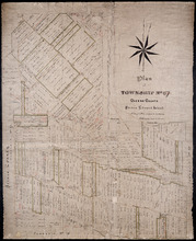
Plan of Township No. 67 Queens County Prince Edward Island: A Copy of a Plan compiled by Geo.…
Description: A copy of a plan of Lot 67 compiled by Geo. Wright, 1858, slightly altered to agree with Meacham's Atlas (No.179). Shows names of residents and acreage, lots, streets and roads, and post offices. more
Province: Prince Edward Island
Type: cadastral maps
Date Created: 1885-07
Plan Shewing the division of Pasture Lots Nos. 61, 62, 70 & 71 in the Royalty of Charlotte Town
Description: Plan showing the division of Pasture or Royalty Lots No.61, No.62, No.70 and No.71 in the Royalty of Charlottetown.
Province: Prince Edward Island
Plan of building lots on the west side of Hillsborough Street, Charlottetown
Description: Plan of building lots on the west side of Hillsborough Street between Grafton and Richmond Streets, Charlottetown. Town Lots No.58, No.59, No.60 and No.95, No.96, No.97 in the 2nd Hund.
Province: Prince Edward Island
Type: cartograms map
Plan of the subdivision of property owned by Mrs. John Longworth in the Commons of Charlottetown:…
Description: Plan of the subdivision of property owned by Mrs. John Longworth in the Commons of Charlottetown, Common Lot No.29. Plan made under the instructions of H.J. Palmer, Trustee for Mrs. John Longworth. (… more
Province: Prince Edward Island
Type: cadastral maps
Date Created: 1923-07-19
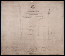
Part of Common Lot No. 22.
Description: Plan of part of Common Lot No.22, Charlottetown.
Province: Prince Edward Island
Type: cadastral maps
Date Created: 1886
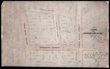
No. 3 Plan of a Tract of Land Appropriated by the Commissioners of the Water-works of Charlottetown
Description: Plan of a tract of land in Charlottetown Royalty appropriated by the Commissioners of the Water-works of Charlottetown. (No.3) (Also No.104). Also shown are landowners and acreage.
Province: Prince Edward Island
Type: cadastral maps
Reserved or Settlement road on Lot 5
Description: Plan of part of Lot 5. The farms on the north side of the Reserved or Settlement Road. The map shows 20 parcels of land on the north side of the Reserve or Settlement Road in the western portion of… more
Province: Prince Edward Island
Type: cadastral maps
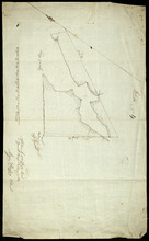
Plan Shewing the Situation of Plot No. 94 on Lot or Township No. 15
Description: Plan of part of Lot 15 (No.74). Shows the situation of Plot No.94, the property of John MacInally. 77 acres. MacInally's plot is shaded green. Map also shows Joseph Gallant's Plot No. 93 to… more
Province: Prince Edward Island
Type: cadastral maps
Plan of 50 Acres of Land being half of Lot No. 171 in the Occupation of John Rechore in Township No…
Description: Plan of part of Lot 15. 50 acres of land, part of 171 in the occupation of John Rechore. Also shows (sub) lots 170, 172, 173 and 174. Copied from office plan of Lot 15. (No.3)
Province: Prince Edward Island
Type: cadastral maps
Date Created: 1851-06-03
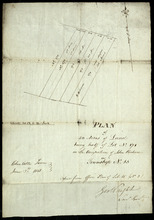
Plan of 500 Acres Land in Egmont Bay 7th February 1814
Description: The map shows 500 acres of land around the mouth of the Haldimand River in Egmont Bay, northeast of Cape Egmont. Plan of part of Lot 15 (No.4).
Province: Prince Edward Island
Date Created: 1814-02-07
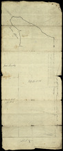
Half Lot No. 18
Description: Plan of the eastern half of Lot 18 (No.3). Mainly outline.
Province: Prince Edward Island
Plan Shewing the position of Common Lot No. 18: from actual survey by Joseph Ball
Description: Plan of the part of Charlottetown showing the position of Common Lot No. 18 on the west side of West Street. Gives names of residents on that side of the street. Shows numbered common lots in the… more
Province: Prince Edward Island
Type: cadastral maps
Part of Lot 18
Description: Plan of part of Lot 18 (No.6). Two Ramsay properties, each 100 acres in size, along Oyster Cove in Lot 18. Sandy and/or marshy areas shown with stippling/shading. North arrow.
Province: Prince Edward Island
Type: cadastral maps
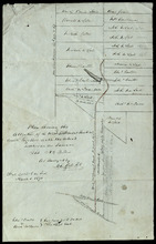
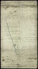
Plan Shewing the Alteration of the West Settlement Road "as colored" together with the…
Description: Plan showing the alteration of the West Settlement Road together with the actual settlers on the same. Lot 22. The maps shows an alteration to a portion of the West Settlement Road in Lot 22. The… more
Province: Prince Edward Island
Type: cadastral maps
Date Created: 1870-03-01
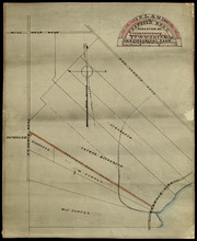
Plan of Proposed Road on A. Dickerson's Farm Township No. 23: Surveyed by John P. Nicholson P…
Description: Plan of proposed road on A. Dickerson's Farm on Lot 23. (No.53). The plan shows a proposed new road, coloured orange, through Arthur Dickerson's farm between Rennie Road and St. Mary's… more
Province: Prince Edward Island
Type: engineering maps
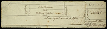
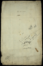
Part of Lot 25
Description: Plan of part of Lot 25 (No.4). Thompson-Taylor land. This item consists of 2 maps——on separate pieces of paper——of the parcels of land belonging to John Thompson (200 acres) and William Taylor (320… more
Province: Prince Edward Island
Type: cadastral maps
Date Created: 1809-11-20
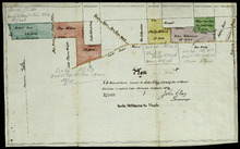
Plan of 75 Acres of land leased to John Clay, showing the different divisions in which it was…
Description: Plan of part of Lot 26. The plan shows 75 acres of land in the western part of Lot 26 leased to John Clay and then later divided and conveyed to other individuals. The plan shows names of residents… more
Province: Prince Edward Island
Type: cadastral maps
Date Created: 1878-08-05
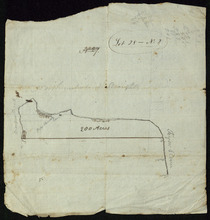
Lot 28 -- No. 2
Description: Plan of part of Lot 28 (No.2). The map shows 200 acres of land along the Northumberland Strait between Crapuad Creek and the Tryon River in Lot 28. Areas that appear to be marshes are indicated with… more
Province: Prince Edward Island
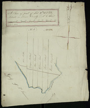
A Plan of part of Lot No. XXVIII. Situate in Prince County P. E. Island
Description: Plan of part of Lot 28 (No.3). The map shows 6 parcels of land with residents' names at Cape Traverse in Lot 28. The Northumberland Strait (which is labelled as the Gulf of St. Lawrence) is… more
Province: Prince Edward Island
Type: cadastral maps