Displaying 1 - 10 of 10

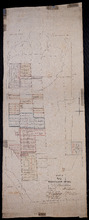
Plan of Part of the Railway Line on Lots No 17.
Description: Plan of part of the Railway Line on Lot 17. Appropriations from the French Purchase to the Linkletter Road. The map shows roads, residents and acreage.
Province: Prince Edward Island
Type: cadastral maps, transportation maps
Date Created: 1872-04-29
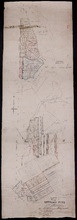
Railway appropriations from Hunter River to Clyde Station: Lots 22 and 23
Description: Railway appropriations from Hunter River to Clyde Station. Lots 22 and 23. The map shows residents and acreage, roads, stations, ponds, and foliage.
Province: Prince Edward Island
Type: cadastral maps
Date Created: 1872

Plan Alterations of Railway on Lot 17 and Station Grounds at Summerside.
Description: Plan of Alterations of the Railway on Lot 17 and the Station Grounds at Summerside. The map shows lots, residents, streets, wharfs, and buildings.
Province: Prince Edward Island
Type: cadastral maps
Date Created: 1872-10-10

Common Lot No 21 as divided into Building Lots
Description: Plan of Common Lot No.21. Charlottetown as divided into building lots. (No.380) The map shows lots, acreage and roads/streets.
Province: Prince Edward Island
Type: cadastral maps
Date Created: 1872-08
Plan "B" part of Township No. 33. as divided amongst the Children of the late Alfred…
Description: Plan of part of Lot 33 as divided amongst the children of the late Alfred Winsloe. Plan B. (No.87). The map also shows Rustico and Covhead Bays, along with Brackley Point, Union, Malpeque, and… more
Province: Prince Edward Island
Type: cadastral maps
Date Created: 1872-06-11
Plan "A" Part of Township No. 24: as divided amongst the children of the late Alfred…
Description: Plan "A" part of Lot 24 as divided amongst the children of the late Alfred Winsloe (No.64). Shows names of residents and acreage, bodies of water such as rivers, creeks, roads, and a… more
Province: Prince Edward Island
Type: cadastral maps
Date Created: 1872-06-11
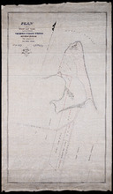
Plan of Shore and Land connected with The Beach Fishery Station Murray Harbour: The Property of Hon…
Description: Plan of part of Lot 64. The shore and land connected with the Beach Fishery Station, Murray Harbour. The property of the Hon. David Davies. The map shows lots, residents, bodies of water, and roads.
Province: Prince Edward Island
Type: cadastral maps
Date Created: 1872-10-29

Plan of Part of Railway Line on Lot No. 16
Description: Plan of part of the Railway Line on Lot 16. The map shows roads, lots, water, and residents.
Province: Prince Edward Island
Type: cadastral maps
Date Created: 1872-04-30

Plan of Part of the Railway Line on Lots No. 16 and 17
Description: Plan of part of the Railway Line on Lots 16 and 17. Appropriations from Lot 16 to the French purchase. The map shows roads, lots, residents, and acreage.
Province: Prince Edward Island
Type: cadastral maps
Date Created: 1872-04-29

Plan of Part of the Railway Line on Lot No. 17: Shewing the Stations Grounds at Summerside.
Description: Plan of part of the Railway Line on Lot 17 showing the Station Grounds at Summerside (No.2). Former location of the appropriations from Linkletter Road into Summerside. The map shows roads, lots,… more
Province: Prince Edward Island
Type: cadastral maps
Date Created: 1872-04-29