Displaying 1 - 2 of 2
Plan of Township No. 7 the property of R.Bruce Stewart: Drawn by R. Stewart 1861 from survey by A.…
Description: Plan of Lot 7. The property of R. Bruce Stewart (No.23). Surveyed by A. Anderson and others, and drawn by R. Stewart. The map shows lots, residents, and roads.
Province: Prince Edward Island
Type: cadastral maps
Date Created: 1861

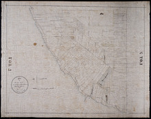
Plan of Township No. 30 belonging to R. Bruce Stewart, Drawn by Robt. Stewart 1861 from surveys…
Description: The map shows Lot 30 divided into numbered sub-lots. There are nine different series of sub-lot numbers which are colour-coded according to the map legend. The different colours represent Line Road,… more
Province: Prince Edward Island
Type: cadastral maps
Date Created: 1861