Displaying 1 - 4 of 4
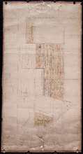
Lot 8
Description: Plan of the eastern part of Lot 8 (No.24). Ramsay Estate. Shows names of some residents, acreage, and some land conveyance references, rivers, roads, and sand hills.
Province: Prince Edward Island
Type: cadastral maps

A Trace of West Coast, Prince Edward Island: from the Survey by Capt. Bayfield, R.N. furnished at…
Description: Plan of the West Coast of Prince Edward Island from the survey by Capt. Bayfield furnished at the request of a Committee of the House of Assembly, March 18, 1842. The coast line marked in red has… more
Province: Prince Edward Island
Type: cadastral maps
Date Created: 1842
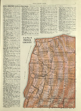
Lot No. 8: Prince County
Description: The map shows Lot 8 in Prince County. Shown are the Nothumberland Strait, Wolf Inlet, Landowners, acreage, and roads.
Publisher: Cummins Map Co.
Province: Prince Edward Island
Type: cadastral maps
Date Issued (Source): 1927

Plan of Lot Eight: Prince Co., P.E.I.
Description: The map shows lot 8 in Prince county. Shown are roads, landowners and acreage, rivers, Northumberland strait, ponds, lighthouses, post offices, churches, mills, and businesses. Compass.
Publisher: J. H. Meacham & company
Province: Prince Edward Island
Type: cadastral maps
Date Issued (Source): 1880