Displaying 1 - 5 of 5
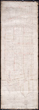
Plan of Lot or Township No. 58: Copied from Surveys of Rodk. Campbell. L. S. by Owen Curtis. L. S.
Description: Plan of Lot 58 (No.155). Shows names of residents, acreage, and land conveyance references. Surveyed by Rod'k Campbell and copied by Owen Curtis. The map shows roads, and bodies of water such as… more
Province: Prince Edward Island
Type: cadastral maps
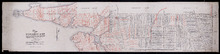
Plan of Township No. 58: Compiled from the proprietors plans and Meacham's Atlas, and from the…
Description: Plan of Lot 58 compiled from the proprietors' plans and Meacham's Atlas and from the descriptions in leases and registered deeds with additions and corrections from various surveys made… more
Province: Prince Edward Island
Type: cadastral maps
Date Created: 1916
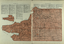
Lots 57 and 58: Queens County
Description: The map shows lots 57 and 58 in Queens county. Shown are Pinette Harbour, Northumberland Strait, Orwell Bay, rivers, roads, railroads, landowners,and acreage.
Publisher: Cummins Map Co.
Province: Prince Edward Island
Type: cadastral maps
Date Issued (Source): 1927
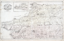
Plan of Lots Fifty Seven & Fifty Eight: Queens Co., P.E.I.
Description: The map shows lots 57 & 58 in Queens county. Includes an inset map of Prim Island / Point Prim. Shown are roads, landowners and acreage, crosses, rivers, ponds, creeks, bays, coves, sand, wharfs… more
Publisher: J. H. Meacham & company
Province: Prince Edward Island
Type: cadastral maps
Date Issued (Source): 1880

Montague Bridge Lots 59 & 52: Kings Co., P.E.I.
Description: The map shows lots 59 & 52 in Montague Bridge, Kings county. Shown are rivers, wharfs, shipyards, roads, landowners and acreage, halls, churches, buildings and businesses. Compass.
Publisher: J. H. Meacham & company
Province: Prince Edward Island
Type: cadastral maps
Date Issued (Source): 1880