Displaying 1 - 9 of 9
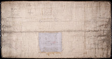
Plan of Part of Township No. 49. Bedford Parish. Queens County. P. E. Island.
Description: Plan of part of Lot 49 (No.135). One of the plans referred to in the deed from Sir Edward, William, and Laura Cunard to the Commissioner of Public Lands, July 13, 1866. The portion of land intended… more
Province: Prince Edward Island
Type: cadastral maps
Date Created: 1850
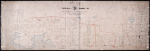
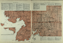
Plan of Township Number 49. Shewing "Cunard" portion borderd. yellow. "Loan Act…
Description: Plan of Lot 49 showing Cunard portion bordered yellow, Loan Act Land bordered green, and remainder of Township (No.134). Copied from Meacham's Atlas by Owen Curtis. Shows names of residents,… more
Province: Prince Edward Island
Type: cadastral maps
Date Created: 1883-08
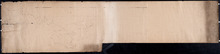
Plan of the division line between Lots 48 and 49
Description: Plan of the division line between Lots 48 and 49. The map shows lots, residents, roads, and bodies of water.
Province: Prince Edward Island
Type: cadastral maps
Date Created: 1841-06
Plan showing the point of commencement of the division line between Lots 48 and 49, established by…
Description: Plan showing the point of commencement of the division line between Lots 48 and 49, established by the Commissioners under the Boundary Bill, July 30, 1840. The map shows lots, residents, roads,… more
Province: Prince Edward Island
Type: cadastral maps
Date Created: 1840-08
Plan of Lot 49
Description: Plan of Lot 49 (No.6). Outline.
Province: Prince Edward Island
Type: cadastral maps
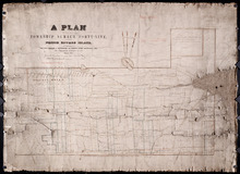
Plan of that part of Township Number Forty-nine, in Prince Edward Island, the Property of the Hon.…
Description: Plan of part of Lot 49, the property of the Hon. Edward C. Haythorne and Robert Poore Haythorne. Tracts shaded green sold with the Act 28 Vic. Cap.5. (No.133). Shows names of residents and acreage,… more
Province: Prince Edward Island
Type: cadastral maps
Date Created: 1857-01
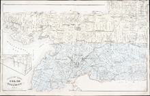
Lots 49 and 50: Queens County
Description: The map shows lots 49 and 50 in Queens county. Shown are bays, Governor Island, points, rivers, roads, railroads, landowners, and acreage.
Publisher: Cummins Map Co.
Province: Prince Edward Island
Type: cadastral maps
Date Issued (Source): 1927
Plan of Lots 49 & 50: Queens Co., P.E.I.
Description: The map shows lot 49 & 50 in Queens County. Shown are roads, landowners and acreage, lakes, bays, coves, wharfs, post offices, churches, and schools. Graphic compass
Publisher: J. H. Meacham & company
Province: Prince Edward Island
Type: cadastral maps
Date Issued (Source): 1880

Montague Bridge Lots 59 & 52: Kings Co., P.E.I.
Description: The map shows lots 59 & 52 in Montague Bridge, Kings county. Shown are rivers, wharfs, shipyards, roads, landowners and acreage, halls, churches, buildings and businesses. Compass.
Publisher: J. H. Meacham & company
Province: Prince Edward Island
Type: cadastral maps
Date Issued (Source): 1880