Displaying 1 - 8 of 8
Plan of Township No. 44. Corrected from Surveys by Owen Curtis, J. C. Underhay and others. By Thos…
Description: Plan of Lot 44 (No.118) corrected by Thomas MacKinlay from surveys by Owen Curtis, J.C. Underhay and others. Cunard Estate. Shows some residents' names, acreage, and land conveyance references,… more
Province: Prince Edward Island
Type: cadastral maps
Date Created: 1887-09
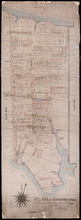
Plan of Township No. 44.
Description: Plan of Lot 44 (No.120). Cunard Estate. Shows names and acreage of some residents, bodies of water such as rivers and gulfs, roads, and a mills (MacGowans).
Province: Prince Edward Island
Type: cadastral maps
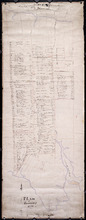
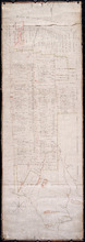
Plan of Lot 44
Description: Plan of Lot 44. Old plan referred to in deed from Sir Ed. Cunard and others to the Commissioner for Public Lands, dated 13 July, 1866.
Province: Prince Edward Island
Type: cadastral maps
Date Created: 1866
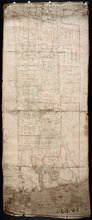
Plan of part of Lot 44
Description: Plan of part of Lot 44. Area east of the Bear River Road. Shows names of residents.
Province: Prince Edward Island
Type: cadastral maps
Plan of Lot 44 (No.119)
Description: Plan of Lot 44 (No.119). Cunard Estate. Shows names of some residents, acreage, and some land conveyance references, bodies of water such as the Gulf of St. Lawrence, rivers, roads, and a nautical… more
Province: Prince Edward Island
Type: cadastral maps
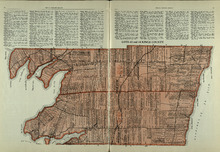
Lots 43 and 44 : Kings County
Description: The map shows lots 43 and 44 in Kings county. Shown are the Gulf of St. Lawrence, bays, points, rivers, landowners, acreage, roads, and railroads.
Publisher: Cummins Map Co.
Province: Prince Edward Island
Type: cadastral maps
Date Issued (Source): 1927
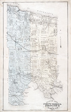
Plan of Lots Fourty Three & Fourty Four: Kings Co., P.E.I.
Description: The map shows lots 43 & 44 in Kings county. Shown are bays, gulfs, rivers, coves, capes, roads, railroads and stations, landowners and acreage, crosses, post offices, churches, and factories.… more
Publisher: J. H. Meacham & company
Province: Prince Edward Island
Type: cadastral maps
Date Issued (Source): 1880
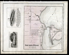
Souris West Lot 44: Kings Co., P.E.I.
Description: The map shows Lot 44 in Souris West, Kings county. Shown are a bay, harbour, river, railroad, landowners, roads, houses and buildings, school houses, businesses, and shipyards. Compass.
Publisher: J. H. Meacham & company
Province: Prince Edward Island
Type: cadastral maps
Date Issued: 1880
Date Issued (Source): 1880