Displaying 1 - 9 of 9
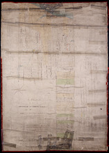
A Plan of Lot or Township No. 43, Comprising the Haviland, Townsend, and Worrell Estates. Compiled…
Description: Plan of Lot 43 (No.116) comprising the Haviland, Townshend, and Worrell Estates. Completed from the surveys of J. Ball and J.C. Underhay by Owen Curtis. Shows names of residents, acreage, and land… more
Province: Prince Edward Island
Type: cadastral maps
Date Created: 1876-08

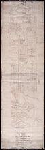
Lot 43: No. 1
Description: Plan of Lot 43 (No.1), showing Bay Fortune, Rollo Bay and North Shore areas.
Province: Prince Edward Island
Type: cadastral maps
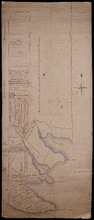
Lot 43: Plan of that part of Division No. 1 Shaded Green on Lot or Township No. 43 containing 3467…
Description: Plan of that part of Lot 43 containing 3467 acres purchased by the Government.
Province: Prince Edward Island
Type: cadastral maps
Part of Lot 43
Description: Plan of part of Lot 43 (No.117). Townshend Estate.
Province: Prince Edward Island
Type: cadastral maps
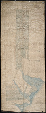
Plan of the southern part of Lot 43
Description: Plan of the southern part of Lot 43. Shows names of residents and acreage, bodies of water such as rivers (Fortune), bays (Rollo), capes, roads, division lines, and a nautical compass. (Townshend)
Province: Prince Edward Island
Type: cadastral maps
A Plan of Part of Township No. Forty Three. The Property of Hon. T. H. Haviland. Surveyed October…
Description: Plan of part of Lot 43. The property of Hon. T.H. Haviland. One of the plans referred to in the Deed from Hon. T.H. Haviland and wife to the Commissioner of Public Lands, 1869. Shows names and… more
Province: Prince Edward Island
Type: cadastral maps
Date Created: 1868-10
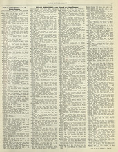
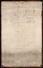
Rural Directory - Lots 42 - 44, Kings County
Description: A directory listing of residents of lots 42, 43, and 44
Publisher: Cummins Map Co.
Province: Prince Edward Island
Type: text
Date Issued (Source): 1927
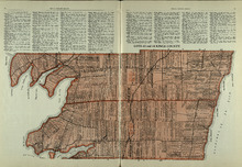
Lots 43 and 44 : Kings County
Description: The map shows lots 43 and 44 in Kings county. Shown are the Gulf of St. Lawrence, bays, points, rivers, landowners, acreage, roads, and railroads.
Publisher: Cummins Map Co.
Province: Prince Edward Island
Type: cadastral maps
Date Issued (Source): 1927
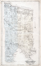
Plan of Lots Fourty Three & Fourty Four: Kings Co., P.E.I.
Description: The map shows lots 43 & 44 in Kings county. Shown are bays, gulfs, rivers, coves, capes, roads, railroads and stations, landowners and acreage, crosses, post offices, churches, and factories.… more
Publisher: J. H. Meacham & company
Province: Prince Edward Island
Type: cadastral maps
Date Issued (Source): 1880