Displaying 1 - 3 of 3
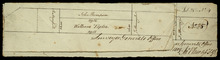
Part of Lot 25
Description: Plan of part of Lot 25 (No.4). Thompson-Taylor land. This item consists of 2 maps——on separate pieces of paper——of the parcels of land belonging to John Thompson (200 acres) and William Taylor (320… more
Province: Prince Edward Island
Type: cadastral maps
Date Created: 1809-11-20
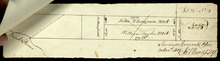
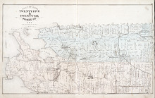
Plan of Lots Twenty Five & Twenty Six: Prince Co., P.E.I.
Description: The map shows lots 25 and 26 in Prince county. The map names roads, landowners and acreage, railroads, post offices, churches, harbours, lighthouses, hotels, coves. and rivers. Graphic compass.
Publisher: J. H. Meacham & company
Province: Prince Edward Island
Type: cadastral maps
Date Issued (Source): 1880