Displaying 1 - 5 of 5
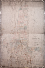
Plan of Township No 15: Taken from the survey of William Cutis (1826) wit alterations and…
Description: Plan of Lot 15 (No.42) taken from the survey of William Curtis (1826) with alterations and corrections from surveys made in 1849 and 1851 by Geo. Wright. Color code shows Crown Lands and lands… more
Province: Prince Edward Island
Type: cadastral maps
Date Created: 1851
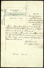
Plan Shewing the Situation of Plot No. 94 on Lot or Township No. 15
Description: Plan of part of Lot 15 (No.74). Shows the situation of Plot No.94, the property of John MacInally. 77 acres. MacInally's plot is shaded green. Map also shows Joseph Gallant's Plot No. 93 to… more
Province: Prince Edward Island
Type: cadastral maps
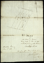
Plan of 50 Acres of Land being half of Lot No. 171 in the Occupation of John Rechore in Township No…
Description: Plan of part of Lot 15. 50 acres of land, part of 171 in the occupation of John Rechore. Also shows (sub) lots 170, 172, 173 and 174. Copied from office plan of Lot 15. (No.3)
Province: Prince Edward Island
Type: cadastral maps
Date Created: 1851-06-03
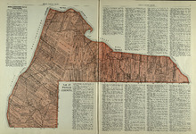
Lot 15: Prince County
Description: The map shows lot 15 in Prince county. Shown are Red Head, Cape Egmont, Egmont Bay, the Northumberland Strait, rivers, landowners, acreage, and roads.
Publisher: Cummins Map Co.
Province: Prince Edward Island
Type: cadastral maps
Date Issued (Source): 1927
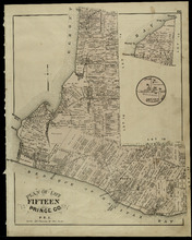
Plan of Lot Fifteen: Prince Co., P.E.I.
Description: The map shown is lot 15 in Prince county. Shown are byas, wharfs, landonwers and acreage, roads, post offices, villages, rivers, coves, a commissioners line, fishing coves, a court house, and stores… more
Publisher: J. H. Meacham & company
Province: Prince Edward Island
Type: cadastral maps
Date Issued (Source): 1880