Displaying 1 - 5 of 5

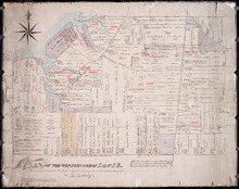
Plan of Lot or Township of No. 13 in Prince County: Prince Edward Island
Description: Plan of Lot 13 (No.35). Yeo Estate. Shows names of residents, acreage, and some land conveyance references. Color code (orange, and yellow) shows willed land and freehold land. The map also shows… more
Province: Prince Edward Island
Type: cadastral maps
Date Created: 1875-10-09
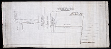
Plan of the Western End of Lot 13.: Corrected from recent Surveys, also shewing Leases, Ledger…
Description: Plan of the western end of Lot 13 (No.37). Yeo Estate. The map shows the western part of Lot 13 divided into parcels of land with names of residents, their acreage amounts and land conveyance… more
Province: Prince Edward Island
Type: cadastral maps
Plan of a new line of road from Victoria West to Western Road Lot 13 Prince Co. P.E.Island
Description: Plan of a new line of road from Victoria West to Western Road. Lot 13. The map shows lots, residents, roads, and rivers.
Province: Prince Edward Island
Type: cadastral maps

Plan of Township No. 13: From a Survey by Alex Anderson Copied from a Plan made by John Clay…
Description: Plan of Lot 13 - Yeo Estate.
Province: Prince Edward Island
Type: cadastral maps
Date Created: 1878

Plan of Lot Thirteen: Prince Co., P.E.I.
Description: Map showing lot thirteen, bordering lots 12, 14 and 15, in Prince county. Shows gulfs, straits, bays, rivers, ponds, creeks, railroads, roads, landowners, acreage, post offices, and buildings.… more
Publisher: J. H. Meacham & company
Province: Prince Edward Island
Type: cadastral maps
Date Issued (Source): 1880