Displaying 1 - 8 of 8
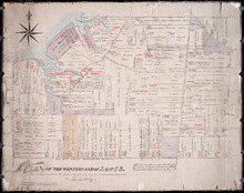
Plan of part of The Western Road.: W. Curtis
Description: (No. 46). The map shows a plan of the Western Road from St. Eleanor's to Lot 10. The road passes through Lots 10, 11, 12, 13, 14, 16 and 17. The map shows part of the Ellis River and other… more
Province: Prince Edward Island
Type: plans

Plan of Lot or Township of No. 13 in Prince County: Prince Edward Island
Description: Plan of Lot 13 (No.35). Yeo Estate. Shows names of residents, acreage, and some land conveyance references. Color code (orange, and yellow) shows willed land and freehold land. The map also shows… more
Province: Prince Edward Island
Type: cadastral maps
Date Created: 1875-10-09
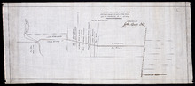
Plan of the Western End of Lot 13.: Corrected from recent Surveys, also shewing Leases, Ledger…
Description: Plan of the western end of Lot 13 (No.37). Yeo Estate. The map shows the western part of Lot 13 divided into parcels of land with names of residents, their acreage amounts and land conveyance… more
Province: Prince Edward Island
Type: cadastral maps
Plan of a new line of road from Victoria West to Western Road Lot 13 Prince Co. P.E.Island
Description: Plan of a new line of road from Victoria West to Western Road. Lot 13. The map shows lots, residents, roads, and rivers.
Province: Prince Edward Island
Type: cadastral maps

Plan of Township No. 13: From a Survey by Alex Anderson Copied from a Plan made by John Clay…
Description: Plan of Lot 13 - Yeo Estate.
Province: Prince Edward Island
Type: cadastral maps
Date Created: 1878
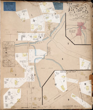
Tyne Valley P.E.I.: Novr. 1897. 1 Mile West of Port Hill Station. Population 300. No Appliances.…
Description: This is a fire insurance plan of Tyne Valley. It was created in 1897, revised to 1903, and then revised again to October, 1910. It shows the town in two (2) sections that are intended to be… more
Publisher: Chas. E. Goad, Civil Engineer
Province: Prince Edward Island
Type: fire insurance maps
Date Created: 1897-11
Date Modified: 1903-07, 1910-10
Date Issued (Source): 1888
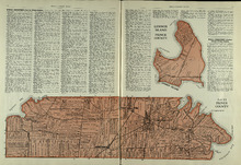
Lot 13, Lennox Island: Prince County
Description: The map shows Lot 13 in Prince county. Shown are bays, roads, creeks, and towns. Also shown in a smaller map at the top is Lennox Island. Shown there are landowners, peat bogs, and Gull, Salt Grass,… more
Publisher: Cummins Map Co.
Province: Prince Edward Island
Date Issued (Source): 1927

Plan of Lot Thirteen: Prince Co., P.E.I.
Description: Map showing lot thirteen, bordering lots 12, 14 and 15, in Prince county. Shows gulfs, straits, bays, rivers, ponds, creeks, railroads, roads, landowners, acreage, post offices, and buildings.… more
Publisher: J. H. Meacham & company
Province: Prince Edward Island
Type: cadastral maps
Date Issued (Source): 1880