Displaying 1 - 3 of 3

A plan of Charlottetown, the capital of the Island delineated by order of Walter Patterson,…
Description: A plan of Charlottetown, the capital of the Island delineated by order of Walter Patterson, Governor of the said Island (No.2). Includes Charlottetown Common and Royalty. Shows names of some… more
Province: Prince Edward Island
Type: cadastral maps
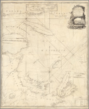
A New Chart of the Gulf of St. Lawrence Compiled from the Original Drawings of Actual Surveys
Description: The most accurate chart of the Gulf of St. Lawrence in 1790, especially its depiction of Cape Breton Island. "The Most Detailed Chart of the St. Lawrence River to Date Fine example of Thomas… more
Publisher: William Faden
Province: Prince Edward Island, Nova Scotia, New Brunswick, Quebec
Type: nautical charts
Date Created: 1790
A Plan of Lot 18: situated in Prince County in the Island of St. John enlarged and Drawn from the…
Description: Sketch plan of Lot 18 (Plan No.46) showing property of Peter Stewart, Robert Stewart, and Wm. Allanby. Surveyed by Thomas Wright. Office copy by Jos. Ball and certified by Geo. Wright. Original was… more
Province: Prince Edward Island
Type: cadastral maps
Date Created: 1847-04-06