Displaying 1 - 3 of 3

Plan of Township No. 67, and its environs.: Compiled from Surveys by Geo. Wright; H.J. Cundall;…
Description: Plan of Lot 67 and its environs. Compiled from surveys by Geo. Wright, H.J. Cundall, Joseph Ball, and Owen Curtis. Drawn by Thomas MacKinlay. Shows names of some residents, roads, railroads, bodies… more
Province: Prince Edward Island
Type: cadastral maps
Date Created: 1877-08-01
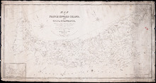
Map of Prince Edward Island, in the Gulf of St. Lawrence: Comprising the latest Topographical…
Description: Map of Prince Edward Island by George Wright, Surveyor General, 1852. Shows mail routes, roads, churches, water mills, population, boundaries, and post offices.
Province: Prince Edward Island
Type: cadastral maps
Date Created: 1852
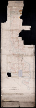
Plan of Township No. 55: From various Surveys made between the Years 1818 and 1845
Description: The map is a Plan of Township No. 55. The mqp shows bodies of water such as the Cardigan River, and Boughton River, lots, landowers, acreage, and Boughton Island.
Province: Prince Edward Island
Type: cadastral maps
Date Created: 1848-03-21