Displaying 1 - 4 of 4
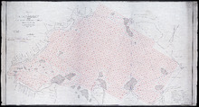
Plan of Richmond Bay from Grand River to Malpeque Harbour: showing location of Oyster Beds and…
Description: Plan of Richmond Bay from Grand River to Malpeque Harbour showing location of Oyster Beds and subdivisions for leasing purposes. (No.2) The map shows resdients, lots, measurements, islands, rivers,… more
Province: Prince Edward Island
Type: cadastral maps
Date Created: 1912-10-14
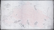
Plan of Richmond Bay from Grand River to Malpeque Harbour: Showing location of Oyster Beds and…
Description: Plan of Richmond Bay from Grand River to Malpeque Harbour showing location of Oyster Beds and subdivisions for leasing purposes. (No.2) The map shows residents, lots, measurements, islands, ponds and… more
Province: Prince Edward Island
Type: cadastral maps
Date Created: 1912-10-14
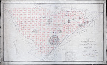
Plan of Richmond Bay from Curtain Island to Malpeque Wharf: Showing location of Oyster Beds and…
Description: Plan of Richmond Bay from Curtain Island to Malpeque Wharf showing location of Oyster Beds and subdivision for leasing purposes. (No.3) The map shows residents, lots, measurements, and islands.
Province: Prince Edward Island
Type: cadastral maps
Date Created: 1912-10-14

Plan of Richmond Bay from Curtain Island to Locke Shore : Showing location of Oyster Beds and…
Description: Plan of Richmond Bay from Curtain Island to Locke Shore showing location of Oyster Beds and subdivisions for leasing purposes. (No.1) The map shows residents, lots, measurements, islands, and rivers.
Province: Prince Edward Island
Type: cadastral maps
Date Created: 1912-10-14