Displaying 1 - 3 of 3
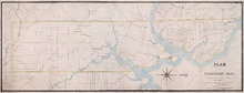
Plan of Township No. 21 and its connexions with adjoining Townships.: Compiled from Surveys by H.J…
Description: Plan of Lot 21 and its connections with adjoining Townships. Shows the names of a few residents north of the South West River. The map also shows many other rivers and creeks, roads, and a nautical… more
Province: Prince Edward Island
Type: cadastral maps
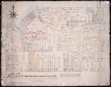
Plan of the Western End of Lot 13.: Corrected from recent Surveys, also shewing Leases, Ledger…
Description: Plan of the western end of Lot 13 (No.37). Yeo Estate. The map shows the western part of Lot 13 divided into parcels of land with names of residents, their acreage amounts and land conveyance… more
Province: Prince Edward Island
Type: cadastral maps
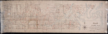
Plan of Township No. 5: Copied from Plans in Land Office, with many addition and corrections from…
Description: Plan of Lot 5 (No.17). Cunard Estate. Copied from plans in Land Office with many additions and corrections from more recent surveys. Also sundry data connecting the lands with their ledger folios,… more
Province: Prince Edward Island
Type: cadastral maps
Date Created: 1886