Displaying 1 - 2 of 2
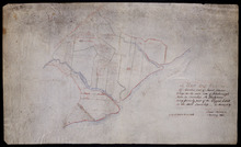
A Map and Survey Of Marshes east of Mount Stewart Bridge on the north side of Hillsborough River in…
Description: A map and survey of marshes east of Mount Stewart Bridge on the north side of Hillsborough River in Lot 37 being formerly part of the Wiggin's Estate. (No.21). Also shown is the Hillsborough… more
Province: Prince Edward Island
Type: cadastral maps
Date Created: 1885-01
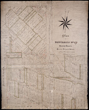
Plan of Township No. 67 Queens County Prince Edward Island: A Copy of a Plan compiled by Geo.…
Description: A copy of a plan of Lot 67 compiled by Geo. Wright, 1858, slightly altered to agree with Meacham's Atlas (No.179). Shows names of residents and acreage, lots, streets and roads, and post offices. more
Province: Prince Edward Island
Type: cadastral maps
Date Created: 1885-07