Displaying 1 - 2 of 2
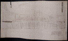
Plan of Lot 48 east of Fullerton's Creek
Description: Plan of that part of Lot 48 east of Fullerton's Creek. Shows names of residents and acreage. (No.13 in Plan Book) (Also, No.924) more
Province: Prince Edward Island
Type: cadastral maps
Date Created: 1874-01
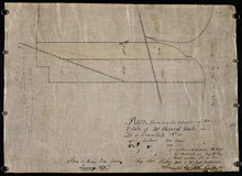
Plan Showing the situation of the Estate of Mr. Clement White on Lot or Township No. 32
Description: Plan of part of Lot 32 (No.21). The estate of Mr. Clement White. The map shows lots, residents, roads, and York (or North) River.
Province: Prince Edward Island
Type: cadastral maps
Date Created: 1874-01