Displaying 1 - 3 of 3

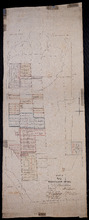
Common Lot No 21 as divided into Building Lots
Description: Plan of Common Lot No.21. Charlottetown as divided into building lots. (No.380) The map shows lots, acreage and roads/streets.
Province: Prince Edward Island
Type: cadastral maps
Date Created: 1872-08
Plan "B" part of Township No. 33. as divided amongst the Children of the late Alfred…
Description: Plan of part of Lot 33 as divided amongst the children of the late Alfred Winsloe. Plan B. (No.87). The map also shows Rustico and Covhead Bays, along with Brackley Point, Union, Malpeque, and… more
Province: Prince Edward Island
Type: cadastral maps
Date Created: 1872-06-11
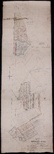
Plan "A" Part of Township No. 24: as divided amongst the children of the late Alfred…
Description: Plan "A" part of Lot 24 as divided amongst the children of the late Alfred Winsloe (No.64). Shows names of residents and acreage, bodies of water such as rivers, creeks, roads, and a… more
Province: Prince Edward Island
Type: cadastral maps
Date Created: 1872-06-11