Displaying 1 - 13 of 13

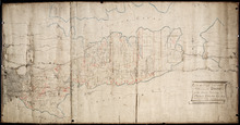
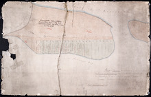
Plan of the East Moriety of Lot or Township No 29: part of the Estate of Lord Vicount Melville…
Description: Plan of the east moiety of Lot 29 (No.79). Part of the estate of Lord Viscount Melville. Shows names of residents, acreage, and a few land conveyance references, bodies of water such as the… more
Province: Prince Edward Island
Type: cadastral maps

Plan of Lot 24 (No.66): Part of the estate of John Hodges Winsloe
Description: Plan of Lot 24 (No.66). Part of the estate of John Hodges Winsloe. Shows names of residents, acreage, and a few land conveyance references, bodies of water such as Gulf of St. Laurence, rivers, roads… more
Province: Prince Edward Island
Type: cadastral maps
Date Created: 1847
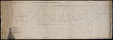
Plan of Half Township No. 65 One of the Estates of the Misses Fanning - Prince Edward Island: From…
Description: Plan of the eastern half of Lot 65 (No. 175). The Misses Fanning Estate. The map shows lots, residents, roads, and bodies of water such as rivers.
Province: Prince Edward Island
Type: cadastral maps
Plan of the Moiety of Lot or Township No 29 of the Estate of Viscount elville situated in Prince…
Description: Plan of the east moiety of Lot 29 (No.2). Part of the estate of Lord Viscount Melville. The map shows lots, residents, roads, and bodies of water such as rivers.
Province: Prince Edward Island
Type: cadastral maps
Plan of the division line between Lots 48 and 49
Description: Plan of the division line between Lots 48 and 49. The map shows lots, residents, roads, and bodies of water.
Province: Prince Edward Island
Type: cadastral maps
Date Created: 1841-06
Plan of the division line between Lots 31 and 65, the commencement of which was set by the…
Description: Plan of the division line between Lots 31 and 65, the commencement of which was set by the Commissioners for establishing boundary lines. (No.1) The map shows lots, roads, and rivers.
Province: Prince Edward Island
Type: cadastral maps
Date Created: 1837-08-26
Plan showing the point of commencement of the division line between Lots 48 and 49, established by…
Description: Plan showing the point of commencement of the division line between Lots 48 and 49, established by the Commissioners under the Boundary Bill, July 30, 1840. The map shows lots, residents, roads,… more
Province: Prince Edward Island
Type: cadastral maps
Date Created: 1840-08

Plan of Township No. 33 in Prince Edward Island: Part of the Estate of John Hodges Winsloe Esq.…
Description: Plan of Lot 33. Winsloe Estate.
Province: Prince Edward Island
Type: cadastral maps
Date Created: 1834-09-20

Plan of 1390 Acres of Land part of Township No. 65: The property of the Hon,, Smauel Cunard…
Description: Plan of part of Lot 65 (No.172). 1390 acres of land, part of the property of the Hon. Samuel Cunard. One of the plans referred to in the Deed from Sir Edward, William, and Laura Cunard to the… more
Province: Prince Edward Island
Type: cadastral maps
Date Created: 1866-07-13
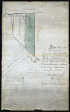
Plan shewing the situation of Malcolm Levingstone's Farm on Lot or Township No. 31, in…
Description: Plan of part of Lot 31. The map shows Malcolm Levingstone's farm of 56 ½ acres, coloured green, on the Baltic Road in Lot 31. The plan also shows the adjoining parcels of land and those on the… more
Province: Prince Edward Island
Type: cadastral maps
Date Created: 1865-12-26
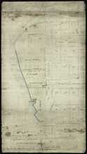
Plan Shewing the position of Common Lot No. 18: from actual survey by Joseph Ball
Description: Plan of the part of Charlottetown showing the position of Common Lot No. 18 on the west side of West Street. Gives names of residents on that side of the street. Shows numbered common lots in the… more
Province: Prince Edward Island
Type: cadastral maps
Plan Shewing the situation of the respective Fishing Establishments, Fronting Harris or Rustico Bay…
Description: Plan of part of Lot 24. Shows situation of the fishing establishments fronting Harris or Rustico Bay. From actual survey. The map shows the Harbours Mouth and Robinsons Island.
Province: Prince Edward Island
Type: cadastral maps
Date Created: 1869-09-02

Plan of Township No. 50 The Estate of the Misses[?] Fanning, Prince Edward Island: From actual…
Description: Plan of Lot 50. Fanning Estate. The map shows lots, residents, bodies of water and roads.
Province: Prince Edward Island
Type: cadastral maps