Displaying 1 - 3 of 3
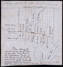
Plan shewing the situation of the line of road leading from Cherry Valley to the contemplated…
Description: Plan showing the situation of the line of road leading from Cherry Valley to the contemplated bridge on Seal River and the 24 chains and 50 links unopened line of road along the line between the… more
Province: Prince Edward Island
Type: cadastral maps

Plan of Town Lots No.74 and No.75 in the 4th Hundred of Town Lots in the city of Charlottetown with…
Description: Plan of Town Lots No.74 and No.75 in the 4th Hundred of Town Lots in the city of Charlottetown with the respective subdivisions delineated thereon. (No.64) Shown are lots and residents.
Province: Prince Edward Island
Type: cadastral maps
Plan of the Division Line between Queens and Prince Counties, & the Southern Boundary of…
Description: Plan of the division line between Queens and Prince Counties and the southern boundary of Lot 25, as established by the Commissioners under the Boundary Line Act. (No.81). The map shows the boundary… more
Province: Prince Edward Island
Type: boundary maps
Date Created: 1835