Displaying 55 - 81 of 201
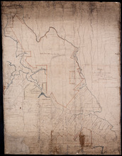
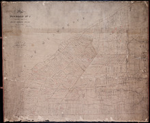
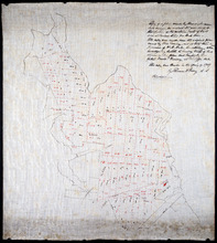
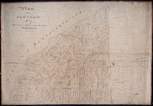
Plan of Part of Lot or Township Number Eleven: by A. Anderson, 1847
Description: Plan of part of Lot 11 (No.31). Stewart Estate. Shows names and acreage of some residents, bodies of water such as rivers, roads, and a compass.
Province: Prince Edward Island
Type: cadastral maps
Date Created: 1847
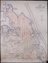
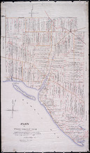
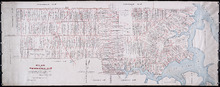
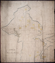
Plan of Township No. 11: compiled from the plans by the late Alexander Anderson L. S on file in the…
Description: The map shows Lot 11 divided into parcels of land with names of residents, their acreage amounts and land conveyance references. Shows the P.E.I. Railway in red, roads in light brown. Bodies of water… more
Province: Prince Edward Island
Type: cadastral maps
Date Created: 1910
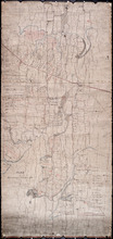
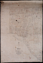
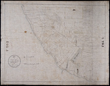
Plan of Township Number 10. Surveyed by John Ball, L. S.
Description: Plan of Lot 10 (No.28). Stewart Estate. Shows names of residents, acreage, and a few land conveyance references, bodies of water such as rivers, lakes, bays, and creeks, roads, and Bird Island.
Province: Prince Edward Island
Type: cadastral maps
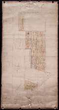
Plan of Township No. 9: Copied from plan furnished by Proprietress with alterations and additions…
Description: Plan of Lot 9 (No.26). Sullivan Estate. Copied from plan furnished by Proprietress with alterations and additions from surveys by Owen Curtis, John Clay &c. Shows names of residents, acreage, and… more
Province: Prince Edward Island
Type: cadastral maps
Date Created: 1883-08-18
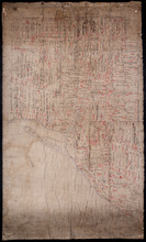
Plan of Township No. 9: compiled from the proprietors' plans and the descriptions in the…
Description: Plan of Lot 9 compiled from the proprietors plans and the descriptions in the leases and deeds, with additions and corrections from the various surveys. The map shows Lot 9 divided into parcels of… more
Province: Prince Edward Island
Type: cadastral maps
Date Created: 1909
Lot 9
Description: Plan of Lot 9 (No.25). Sullivan Estate. Shows names of residents, acreage, and land conveyance references, rivers, roads, and Sandy or Brae Islands.
Province: Prince Edward Island
Type: cadastral maps
Plan of Township No. 9 in Prince Edward Island: The Property of Miss Charlotte Sullivan containing…
Description: Plan of Lot 9 (No.27). The property of Miss Charlotte Sulivan, containing 17300 acres. Shows names of residents and acreage, bodies of water such as rivers, creeks, roads, Sandy or Brae Island, and… more
Province: Prince Edward Island
Type: cadastral maps
Lot 8
Description: Plan of the eastern part of Lot 8 (No.24). Ramsay Estate. Shows names of some residents, acreage, and some land conveyance references, rivers, roads, and sand hills.
Province: Prince Edward Island
Type: cadastral maps
Plan of Township No. 7, Prince County, Prince Edward Island, From Actual Survey by John Clay L. S…
Description: Plan of Lot 7 (No.21). Stewart Estate. Shows names of residents and acreage, bodies of water such as the Gulf of St. Lawrence, ponds, and roads.
Province: Prince Edward Island
Type: cadastral maps
Date Created: 1877-04-09
Plan of Township No. 6: Compiled from plans, leases, deeds, and other documents on file in the Land…
Description: The map shows Lot 6 divided into parcels of land with names of residents, their acreage amounts and land conveyance references handwritten in black and red ink. Shows the P.E.I. Railway in red, roads… more
Province: Prince Edward Island
Type: cadastral maps
Date Created: 1912-01
Plan of Town Lots at Cascumpec Point. Township No. 5.: Compiled and corrected from Surveys by John…
Description: Plan of Town Lots at Cascumpec Point, Lot 5. The map shows Cascumpec Point divided into parcels of land (most of them numbered) with names of residents. Shows land belonging to J. C. Pope outlined in… more
Province: Prince Edward Island
Type: cadastral maps
Date Created: 1877-08-01
Plan of Township No. 5: compiled from plans, leases, deeds, and other documents on file in the Land…
Description: Plan of Lot 5 compiled from plans, leases, deeds, and other documents on file in the Land Office. The map shows Lot 5 divided into parcels of land with names of residents, their acreage amounts and… more
Province: Prince Edward Island
Type: cadastral maps
Date Created: 1911-09

Plan of Lot or Township No. 5 in Prince Edward Island: The Shore and the Division line, coloured…
Description: Plan of Lot 5. The Shore and the Division line, coloured Yellow are according to actual Survey by A. Anderson. Shows names of residents, acreage, and land conveyance references, bodies of water such… more
Province: Prince Edward Island
Type: cadastral maps
Date Created: 1840
Plan of Township No. 5: Copied from Plans in Land Office, with many addition and corrections from…
Description: Plan of Lot 5 (No.17). Cunard Estate. Copied from plans in Land Office with many additions and corrections from more recent surveys. Also sundry data connecting the lands with their ledger folios,… more
Province: Prince Edward Island
Type: cadastral maps
Date Created: 1886

Plan of a proposed new line of road from Middleton Road to Isaac Ive's Millas coloured brown…
Description: Plan of a proposed new line of road from Middleton Road to Isaac Ive's Mill connecting with the road already opened from Searletown to Ive's Mill thro. part of Lot 27. The map shows lots,… more
Province: Prince Edward Island
Type: cadastral maps
Plan of a new line of road from Victoria West to Western Road Lot 13 Prince Co. P.E.Island
Description: Plan of a new line of road from Victoria West to Western Road. Lot 13. The map shows lots, residents, roads, and rivers.
Province: Prince Edward Island
Type: cadastral maps
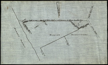
Plan of part of the Linklater Road, Lot 17
Description: Plan of part of the Linklater Road, Lot 17. (Linkletter Road) The map shows lots, residents, and roads.
Province: Prince Edward Island
Type: cadastral maps

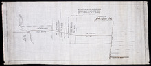
A Plan of Land on Lot or Township No. 17 in Prince County, P. E. Island
Description: A plan of part of Lot 17, the property of J. Weatherbe, Summerside. (No.11). Shown are lots, residents, measurements and roads.
Province: Prince Edward Island
Type: cadastral maps
Date Created: 1857-06

Plan of A Tract of Land situate in Summerside P.E.Island, in the possesion of Mr. Jesse Green, laid…
Description: Plan of a tract of land situated in Summerside and laid off in pasture lots. The property of Mr. Jesse Green. The map shows lots, residents, roads, and acreage.
Province: Prince Edward Island
Type: cadastral maps
Date Created: 1877-04-24
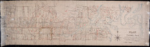
Plan of part of Lot 28, showing the property of William Carruthers bordering on Borden Harbour.
Description: Plan of part of Lot 28, showing the property of William Carruthers bordering on Borden Harbour. The map shows lots, residents, water, and roads.
Province: Prince Edward Island
Type: cadastral maps

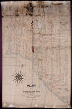
Plan of Lot 5: Mainly Outline
Description: Plan of Lot 5. Mainly outline. Shows names of some residents east of Mill River, lots, and waters.
Province: Prince Edward Island
Type: cadastral maps
Copy of a plan made by Alexander Anderson in 1845 of that portion of the northern part of Lot 11…
Description: Copy of a plan made by Alexander Anderson in 1845 of that portion of the northern part of Lot 11 sold at various times for land taxes. Plan shows property bought by David Ramsay at a Sheriff's… more
Province: Prince Edward Island
Type: cadastral maps
Date Created: 1909
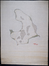
Plan of Lennox Island: Incomplete
Description: Plan of Lennox Island. Incomplete. Shows water and foliage.
Province: Prince Edward Island
Type: cadastral maps
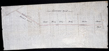
Sketch of parts of Lots 4 and 5
Description: Sketch of parts of Lots 4 and 5. Area along Mill River(?). Shown are lots, and water.
Province: Prince Edward Island
Type: cadastral maps
Plan of Township No. 7 the property of R.Bruce Stewart: Drawn by R. Stewart 1861 from survey by A.…
Description: Plan of Lot 7. The property of R. Bruce Stewart (No.23). Surveyed by A. Anderson and others, and drawn by R. Stewart. The map shows lots, residents, and roads.
Province: Prince Edward Island
Type: cadastral maps
Date Created: 1861
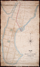
A Plan of Prince Town Royalty: from A Survey made in Nov. 1828
Description: A plan of Prince Town Royalty. Also shows Prince Town. Gives numbers of Town and Royalty Lots. The map shows bodies of water, squares, and towns.
Province: Prince Edward Island
Type: cadastral maps
Date Created: 1828-11
Plan of Township No. 7: Copied from the the Survey of John Clan L.S>
Description: Plan of Lot 7 (No.22). Stewart Estate. Shows names of residents, acreage, and references to land conveyance, roads, and bodies of water. Plan copied by Owen Curtis.
Province: Prince Edward Island
Type: cadastral maps