Displaying 1 - 20 of 20
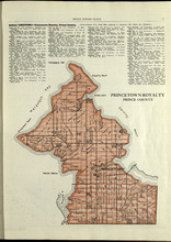
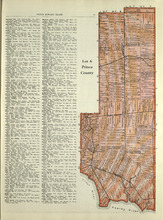
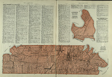
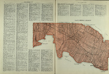
Princetown Royalty: Prince County
Description: The map shows Princetown Royalty in Prince County. Shown are rivers, bays, roads, landowners, acreage, and towns. Atlas of Province of Prince Edward Island, Canada and the World
Publisher: Cummins Map Co.
Province: Prince Edward Island
Type: cadastral maps
Date Issued (Source): 1927
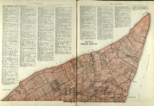
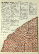
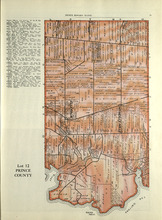
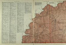
Lot No. 1 : Prince County
Description: The map shows Lot 1 in Prince county. Shown are the Gulf of St. Lawrence, ponds, rivers, creeks, landowners, acreage, roads and a railroad.
Publisher: Cummins Map Co.
Province: Prince Edward Island
Date Issued (Source): 1927
Lots 2 & 3 : Prince County
Description: The map shows lots 2 & 3 in Prince county. Shown are the Gulf of St. Lawrence, capes, ponds, landowners, acreage, rivers, and roads.
Publisher: Cummins Map Co.
Province: Prince Edward Island
Type: cadastral maps
Date Issued (Source): 1927
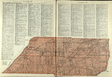
Lots 4 : Prince county
Description: The map shows Lots 4
Publisher: Cummins Map Co.
Province: Prince Edward Island
Type: cadastral maps
Date Issued (Source): 1927
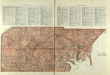
Rural Directory - Lots 4 - 6, Prince County
Description: A directory listing of residents of lots 4, 5, and 6.
Publisher: Cummins Map Co.
Province: Prince Edward Island
Type: text
Date Issued (Source): 1927
Lot 6: Prince County
Description: The map shows Lot 6 in Prince county. Shown are roads, landowners, acreage, railroad, rivers, and Oyster creek
Publisher: Cummins Map Co.
Province: Prince Edward Island
Date Issued (Source): 1927
Lot No. 7: Prince County
Description: The map shows Lot 7 in Prince county. Shown are capes, coves, roads, landowners, and acreage.
Publisher: Cummins Map Co.
Province: Prince Edward Island
Type: cadastral maps
Date Issued (Source): 1927
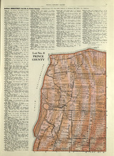
Lot No. 8: Prince County
Description: The map shows Lot 8 in Prince County. Shown are the Nothumberland Strait, Wolf Inlet, Landowners, acreage, and roads.
Publisher: Cummins Map Co.
Province: Prince Edward Island
Type: cadastral maps
Date Issued (Source): 1927

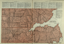
Lot No. 9: Prince County
Description: The map shows Lot 9 in Prince county. Shown are roads, Egmont Bay, Dog Cove, roads, and railroads.
Publisher: Cummins Map Co.
Province: Prince Edward Island
Type: cadastral maps
Date Issued (Source): 1927
Rural Directory - Lots 9 and 10, Prince County
Description: A directory listing of residents of lots 9 and 10.
Publisher: Cummins Map Co.
Province: Prince Edward Island
Type: text
Date Issued (Source): 1927
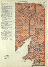
Lot 10: Prince County
Description: The map shows Lot 10 in Prince county. Shown are rivers, roads, landowners, and acreage.
Publisher: Cummins Map Co.
Province: Prince Edward Island
Type: cadastral maps
Date Issued (Source): 1927
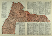
Lot 11: Prince County
Description: The map shows lot 11 in Prince county. Shown are roads, landowners, acreage, the Gulf of St. Lawrenece, Sand Hills, The Narrows, Cascumpeque Baym Foxley River, and Cavendish Inlet.
Publisher: Cummins Map Co.
Province: Prince Edward Island
Type: cadastral maps
Date Issued (Source): 1927
Rural Directory - Lot 12, Prince County
Description: A directory listing of residents of lot 12
Publisher: Cummins Map Co.
Province: Prince Edward Island
Type: text
Date Issued (Source): 1927
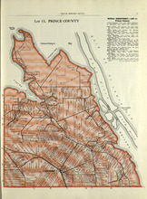
Lot 12: Prince County
Description: The map shows Lot 12 in Prince county. Shown are roads, landowners, acreage, The Narrows, rivers, and a railroad.
Publisher: Cummins Map Co.
Province: Prince Edward Island
Type: cadastral maps
Date Issued (Source): 1927
Lot 13, Lennox Island: Prince County
Description: The map shows Lot 13 in Prince county. Shown are bays, roads, creeks, and towns. Also shown in a smaller map at the top is Lennox Island. Shown there are landowners, peat bogs, and Gull, Salt Grass,… more
Publisher: Cummins Map Co.
Province: Prince Edward Island
Date Issued (Source): 1927
Lot 15: Prince County
Description: The map shows lot 15 in Prince county. Shown are Red Head, Cape Egmont, Egmont Bay, the Northumberland Strait, rivers, landowners, acreage, and roads.
Publisher: Cummins Map Co.
Province: Prince Edward Island
Type: cadastral maps
Date Issued (Source): 1927
Lots 14 and 16 : Prince County
Description: The map shows lots 14 and 16, in Prince county. Shown are bays, ponds, coves, landowners, acreage, rivers, and roads.
Publisher: Cummins Map Co.
Province: Prince Edward Island
Type: cadastral maps
Date Issued (Source): 1927
Lot 17: Prince County
Description: The map shows Lot 17 in Prince county. Shown are byas, coves, landowners, acreage, towns, cities, and roads.
Publisher: Cummins Map Co.
Province: Prince Edward Island
Type: cadastral maps
Date Issued (Source): 1927
Lots 27 and 28: Prince County
Description: The map shows lots 27 and 28 in Prince county. Shown are the Northumberland Strait, points, coves, landowners, acreage, roads, and a railroad.
Publisher: Cummins Map Co.
Province: Prince Edward Island
Type: cadastral maps
Date Issued (Source): 1927
Rural Directory - Lots 27 and 28, Prince County and Lot 67, Queens county
Description: A directory listing of residents of lots 27 and 28 in Prince County and lot 67 in Queens County
Publisher: Cummins Map Co.
Province: Prince Edward Island
Type: text
Date Issued (Source): 1927