Displaying 1 - 27 of 201

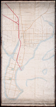
Prince Edward Island Nova Scotia and New Brunswick: Prince, Queens and Kings Counties, P.E.I.…
Description: Prince, Queens and Kings Counties, Prince Edward Island, portions of New Brunswick, Nova Scotia, and Magdalen Islands. It marks counties, parishes, cities, towns, and villages, beaches, marshes, Lots… more
Publisher: Hydrographic and Map Service, Labelle Building
Province: Prince Edward Island, Nova Scotia, New Brunswick, Quebec
Type: cadastral maps
Date Created: 1940

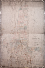
Plan of Lot or Township No 4, in P.E. Island: The shores and the division Lines coloured according…
Description: Plan of Lot 4. The shores and the division lines colored to yellow are according to actual survey. Shows names of some residents, acreage, roads, and bodies of water such as rivers.
Province: Prince Edward Island
Type: cadastral maps
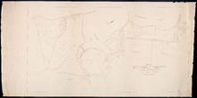
Unfinished plan of Alberton and Cascumpec Point, Lots 4 and 5
Description: Unfinished plan of Alberton and Cascumpec Point, Lots 4 and 5. Mainly outline. Shows churches, station ground, school, and the names of a few residents.
Province: Prince Edward Island
Type: cadastral maps

Plan of Lot No 1 Shewing the Extent of the Fishery Reserve to the Crown and situation of settlers…
Description: Plan of Lot 1 (No.6) showing the extent of the Fishery Reserve to the Crown and situation of settlers thereon. Also the site of the respective fishery establishments of the same, as delineated from… more
Province: Prince Edward Island
Type: cadastral maps
Date Created: 1853-10
Plan of Cape Traverse Branch: Prince Edward Island Railway
Description: Canadian Government Railways, Prince Edward Island. Cape Traverse subdivision. Plans of the Railway right of way from Emerald Junction to Port Borden. Copied from the plans in the Engineer's… more
Province: Prince Edward Island
Type: cadastral maps
Plan of Railway appropriations in Lots 26, 27 and 28
Description: Plan of Railway appropriations in Lots 26, 27 and 28. The map shows lots, roads, residents, and acreage.
Province: Prince Edward Island
Type: cadastral maps, transportation maps

Plan of Part of the Railway Line on Lots No 17.
Description: Plan of part of the Railway Line on Lot 17. Appropriations from the French Purchase to the Linkletter Road. The map shows roads, residents and acreage.
Province: Prince Edward Island
Type: cadastral maps, transportation maps
Date Created: 1872-04-29
Plan-showing the Right of Way : Cape Traverse Branch P.E.I
Description: Plan showing the right of way of the Cape Traverse Branch of the Prince Edward Island Railway. The map shows roads, residents and acreage.
Province: Prince Edward Island
Type: cadastral maps

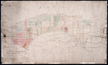
Plan Alterations of Railway on Lot 17 and Station Grounds at Summerside.
Description: Plan of Alterations of the Railway on Lot 17 and the Station Grounds at Summerside. The map shows lots, residents, streets, wharfs, and buildings.
Province: Prince Edward Island
Type: cadastral maps
Date Created: 1872-10-10
Map of Southport and Rosebank, Prince Edward Island: Drawn by C.D. Lambown Sept. 26, 1953
Description: Map of Southport and Rosebank, Lot.48. Shows names of residents, acreage, cities and towns, and Hillsborough River.
Province: Prince Edward Island
Type: cadastral maps
Date Created: 1953-09-26

Map of Prince Edward Island
Description: Map of Prince Edward Island showing school districts(?). The map shows bodies of water and town and cities.
Province: Prince Edward Island
Type: cadastral maps, thematic maps
Date Created: 1971-02-05
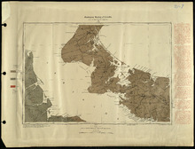
Prince Edward Island
Description: Prince Edward Island. Geological Survey of Canada. The map shows Prince county, roads, bodies of water, cities and towns.
Province: Prince Edward Island
Type: geological maps
Date Created: 1884
Plan of the Cunard and Palmer Estates in Lot or Township No.1.
Description: Plan of Lot 1 (No.1). Cunard and Palmer Estates. Drawn by Owen Curtis. Shows names of residents, acreage, and a few land conveyance references, and roads.
Province: Prince Edward Island
Type: cadastral maps
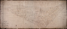
Plan of Township No 15: Taken from the survey of William Cutis (1826) wit alterations and…
Description: Plan of Lot 15 (No.42) taken from the survey of William Curtis (1826) with alterations and corrections from surveys made in 1849 and 1851 by Geo. Wright. Color code shows Crown Lands and lands… more
Province: Prince Edward Island
Type: cadastral maps
Date Created: 1851
Plan of Cascumpec Point As sold by Public Auction in June 1871
Description: Plan of Cascumpec Point, as sold by public auction, June, 1871. The map shows lots, residents, bodies of water such as bays, cities and towns, and roads.
Province: Prince Edward Island
Type: cadastral maps
Date Created: 1871-08

Plan of that portion of the town of Summerside laid off on the front of the farm by Mr. Jesse Green.
Description: Plan of that portion of the town of Summerside laid off on the front of the farm by Mr. Jesse Green. The map shows lots, residents, towns, cities, roads, and bodies of water.
Province: Prince Edward Island
Type: cadastral maps
Date Created: 1868-11-25

Plan of Lot 5
Description: Plan of Lot 5. Shows names of residents and acreage, rivers, creeks, roads, bays and Islands.
Province: Prince Edward Island
Type: cadastral maps

A Plan of Township No 4 Part of the Cunard Estate Prince County P.E.Island
Description: A plan of Lot 4, part of the Cunard Estate. Copied from plans in the Public Lands Department. The map shows lots, residents, bodies of water such as rivers, railways, and roads.
Province: Prince Edward Island
Type: cadastral maps
Date Created: 1885-06

Plan de l'Ȋle de St. Jean au Nord de l'Acadie et dans le Sud du Golfe de St. Laurent.:…
Description: Plan de l'Ȋle de St. Jean. Par Ordre de M. de Sartine, Conseiller d'Etat, Ministre et Secretaire d'Etat au Département de la Marine. The map shows the province of Prince Edward Island… more
Publisher: Sartine, M. de
Province: Prince Edward Island
Type: topographic maps
Date Created: 1778
Part of Lot 12 : copied from Township Plan in Land Office Charlottetown
Description: Plan of part of Lot 12 - North Shore. Shows names of some residents, acreage, roads, creeks, Islands, towns and cities. Copied from Township Plan in the Land Office at Charlottetown.
Province: Prince Edward Island
Type: cadastral maps

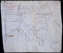
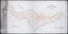
Plan of Richmond Bay from Curtain Island to Locke Shore : Showing location of Oyster Beds and…
Description: Plan of Richmond Bay from Curtain Island to Locke Shore showing location of Oyster Beds and subdivisions for leasing purposes. (No.1) The map shows residents, lots, measurements, islands, and rivers.
Province: Prince Edward Island
Type: cadastral maps
Date Created: 1912-10-14

Plan of Cascumpec Bay: Showing Sub-divisions to be leased for Oyster Culture
Description: Plan of Cascumpec Bay showing sub-divisions to be leased for Oyster Culture. (No.8) The map shows residents, measurements, lots, rivers, and sand hills.
Province: Prince Edward Island
Type: cadastral maps
Date Created: 1913-11-17
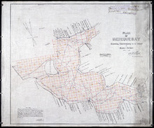
Plan of Bedeque Bay : Showing Sub-divisions to be leased for Oyster Culture
Description: Plan of Bedeque Bay showing sub-divisions to be leased for Oyster Culture. (No.16) The map shows residents, lots, measurements, and Holman's Island. more
Province: Prince Edward Island
Type: cadastral maps
Date Created: 1914-06-01

Plan of Barbara Weit River: Showing Subdivisions to be leased for Oyster Culture.
Description: Plan of Barbara Weit River showing subdivisions to be leased for Oyster Culture. (No.7) The map shows residents, lots, Richmond Bay and measurements.
Province: Prince Edward Island
Type: cadastral maps
Date Created: 1913-09-06
Plan of Foxley River: Showing Subdivisions to be leased for Oyster Culture
Description: Plan of Foxley River showing subdivisions to be leased for Oyster Culture. (No.17). The map shows residents, lots, and measurements.
Province: Prince Edward Island
Type: cadastral maps
Date Created: 1915

Plan of Dockriver: Showing Subdivisions to be leased for Oyster Culture.
Description: Plan of Dock River showing subdivisions to be leased for Oyster Culture. (No.14). The map shows residents, measurements, bays and Fox Island.
Province: Prince Edward Island
Type: cadastral maps
Date Created: 1913-11-17
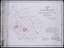
Plan of Oyster Cove: showing subdivisions to be leased for Oyster Culture
Description: Plan of Oyster Cove showing subdivisions to be leased for Oyster Culture. (No.6). The map shows redisents, measurements, and Richmond Bay.
Province: Prince Edward Island
Type: cadastral maps
Date Created: 1913-08-15