Displaying 1 - 7 of 7
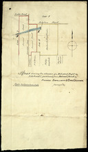
Plan shewing the situation of a Mill-pond Right on Lots 6 and 7, purchased from Samuel Sweet, by…
Description: Plan of part of Lots 6 and 7 showing the situation of a Mill-pond right purchased from Samuel Sweet by Richard Smallman and Chas. Crossman. The mill pond is located in the area where Lots 5, 6 and 7… more
Province: Prince Edward Island
Type: cadastral maps
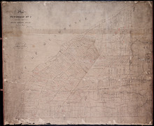
Plan of Township No. 7, Prince County, Prince Edward Island, From Actual Survey by John Clay L. S…
Description: Plan of Lot 7 (No.21). Stewart Estate. Shows names of residents and acreage, bodies of water such as the Gulf of St. Lawrence, ponds, and roads.
Province: Prince Edward Island
Type: cadastral maps
Date Created: 1877-04-09
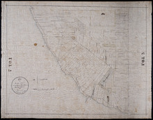
Plan of Township No. 7 the property of R.Bruce Stewart: Drawn by R. Stewart 1861 from survey by A.…
Description: Plan of Lot 7. The property of R. Bruce Stewart (No.23). Surveyed by A. Anderson and others, and drawn by R. Stewart. The map shows lots, residents, and roads.
Province: Prince Edward Island
Type: cadastral maps
Date Created: 1861
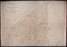
Plan of Township No. 7: Copied from the the Survey of John Clan L.S>
Description: Plan of Lot 7 (No.22). Stewart Estate. Shows names of residents, acreage, and references to land conveyance, roads, and bodies of water. Plan copied by Owen Curtis.
Province: Prince Edward Island
Type: cadastral maps

A Trace of West Coast, Prince Edward Island: from the Survey by Capt. Bayfield, R.N. furnished at…
Description: Plan of the West Coast of Prince Edward Island from the survey by Capt. Bayfield furnished at the request of a Committee of the House of Assembly, March 18, 1842. The coast line marked in red has… more
Province: Prince Edward Island
Type: cadastral maps
Date Created: 1842
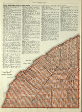
Lot No. 7: Prince County
Description: The map shows Lot 7 in Prince county. Shown are capes, coves, roads, landowners, and acreage.
Publisher: Cummins Map Co.
Province: Prince Edward Island
Type: cadastral maps
Date Issued (Source): 1927

Plan of Lot Seven: Prince Co., P.E.I.
Description: Map showing lot seven, bordering lots 4, 5, 6, and 8 in Prince county. Shows gulfs, railroads, roads, landowners, acreage, post offices, and buildings. Geographical compass
Publisher: J. H. Meacham & company
Province: Prince Edward Island
Type: cadastral maps
Date Issued (Source): 1880