Displaying 1 - 10 of 10

Plan of Part of the Railway Line on Lots No 17.
Description: Plan of part of the Railway Line on Lot 17. Appropriations from the French Purchase to the Linkletter Road. The map shows roads, residents and acreage.
Province: Prince Edward Island
Type: cadastral maps, transportation maps
Date Created: 1872-04-29

Plan Alterations of Railway on Lot 17 and Station Grounds at Summerside.
Description: Plan of Alterations of the Railway on Lot 17 and the Station Grounds at Summerside. The map shows lots, residents, streets, wharfs, and buildings.
Province: Prince Edward Island
Type: cadastral maps
Date Created: 1872-10-10
Plan of part of The Western Road.: W. Curtis
Description: (No. 46). The map shows a plan of the Western Road from St. Eleanor's to Lot 10. The road passes through Lots 10, 11, 12, 13, 14, 16 and 17. The map shows part of the Ellis River and other… more
Province: Prince Edward Island
Type: plans

A Plan of Land on Lot or Township No. 17 in Prince County, P. E. Island
Description: A plan of part of Lot 17, the property of J. Weatherbe, Summerside. (No.11). Shown are lots, residents, measurements and roads.
Province: Prince Edward Island
Type: cadastral maps
Date Created: 1857-06

Plan of Part of the Railway Line on Lots No. 16 and 17
Description: Plan of part of the Railway Line on Lots 16 and 17. Appropriations from Lot 16 to the French purchase. The map shows roads, lots, residents, and acreage.
Province: Prince Edward Island
Type: cadastral maps
Date Created: 1872-04-29

Plan of Part of the Railway Line on Lot No. 17: Shewing the Stations Grounds at Summerside.
Description: Plan of part of the Railway Line on Lot 17 showing the Station Grounds at Summerside (No.2). Former location of the appropriations from Linkletter Road into Summerside. The map shows roads, lots,… more
Province: Prince Edward Island
Type: cadastral maps
Date Created: 1872-04-29
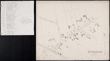
Miscouche, Lot 17
Description: This item consists of a fire insurance plan of the community of Miscouche and an accompanying handwritten text document. The map of Miscouche focuses on the area of the Fifteen Point Road. It shows… more
Province: Prince Edward Island
Type: fire insurance maps
Date Issued (Source): 1888
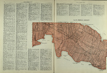
Lot 17: Prince County
Description: The map shows Lot 17 in Prince county. Shown are byas, coves, landowners, acreage, towns, cities, and roads.
Publisher: Cummins Map Co.
Province: Prince Edward Island
Type: cadastral maps
Date Issued (Source): 1927
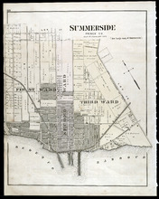
Summerside: Prince Co., P.E.I.
Description: The map shows the city of Summerside. Shown are the wards, a corportion line, landowners and acreage, roads, cemetery, buildings, railroad wharfs, and a harbour.
Publisher: J. H. Meacham & company
Province: Prince Edward Island
Type: cadastral maps
Date Issued (Source): 1880
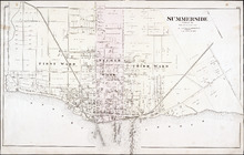
Summerside: Prince Co.
Description: The map shows the city of Summerside. Shown are the wards, roads, landowners and acreage, harbour, barracks, schools, squares, shipyards, railroad and station, and wharfs. Compass.
Publisher: J. H. Meacham & company
Province: Prince Edward Island
Type: cadastral maps
Date Issued (Source): 1880