Displaying 1 - 9 of 9

Plan of Township No. 5: compiled from plans, leases, deeds, and other documents on file in the Land…
Description: Plan of Lot 5 compiled from plans, leases, deeds, and other documents on file in the Land Office. The map shows Lot 5 divided into parcels of land with names of residents, their acreage amounts and… more
Province: Prince Edward Island
Type: cadastral maps
Date Created: 1911-09

Plan of Town Lots at Cascumpec Point. Township No. 5.: Compiled and corrected from Surveys by John…
Description: Plan of Town Lots at Cascumpec Point, Lot 5. The map shows Cascumpec Point divided into parcels of land (most of them numbered) with names of residents. Shows land belonging to J. C. Pope outlined in… more
Province: Prince Edward Island
Type: cadastral maps
Date Created: 1877-08-01

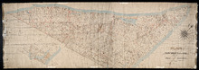
Plan of Cascumpec Point Copied from a Plan in the Public Lands Departt. furnished by John Ball. L.…
Description: Plan of Cascumpec Point, Lot 5. The map shows numbered parcels of land on Cascumpec Point with names of residents and some land conveyance references. The legend indicates that parcels are outlined… more
Province: Prince Edward Island
Type: cadastral maps
Date Created: 1885-06
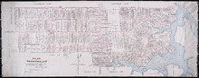
Plan of Township No. 6: Compiled from plans, leases, deeds, and other documents on file in the Land…
Description: The map shows Lot 6 divided into parcels of land with names of residents, their acreage amounts and land conveyance references handwritten in black and red ink. Shows the P.E.I. Railway in red, roads… more
Province: PE
Type: cadastral maps
Date Created: 1912-01
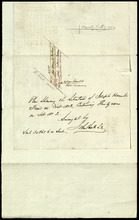
Plan Showing the Situation of Joseph Hammil's Farm on Lot No. 2. Containing Thirty acres on…
Description: Plan of part of Lot 2 showing Joseph Hammill's Farm containing 30 acres. The map shows Joseph Hammill's 30-acre parcel shaded in a greenish colour. It also shows the adjacent parcel of John… more
Province: PE
Type: cadastral maps

Plan of Township No. 9: compiled from the proprietors' plans and the descriptions in the…
Description: Plan of Lot 9 compiled from the proprietors plans and the descriptions in the leases and deeds, with additions and corrections from the various surveys. The map shows Lot 9 divided into parcels of… more
Province: Prince Edward Island
Type: cadastral maps
Date Created: 1909

Plan of Township No. 11: compiled from the plans by the late Alexander Anderson L. S on file in the…
Description: The map shows Lot 11 divided into parcels of land with names of residents, their acreage amounts and land conveyance references. Shows the P.E.I. Railway in red, roads in light brown. Bodies of water… more
Province: Prince Edward Island
Type: cadastral maps
Date Created: 1910
Plan of Lot 1
Description: Plan of Lot 1 comprising the Palmer and part of the Cunard Estates. Surveyed by V.S. Gillis and others. Rolled map on fabric backing. Water is coloured blue. Properties include owner / occupant names… more
Province: Prince Edward Island
Type: cadastral maps
Date Created: Unknown year