Displaying 1 - 1 of 1
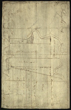
Part of Lot No. 26
Description: Plan of part of Lot 26 (No.3). Plan traced[?] by J. Plaw from a survey by Mr. Major[?]. The maps shows part of Lot 26 (the Centreville area) divided into parcels of land with the names of residents… more
Province: Prince Edward Island
Type: cadastral maps
Date Created: 1810-05-23